Regulation on regional planning in the German exclusive economic zone in the North Sea (AWZ Nordsee-ROV)
Unofficial table of contents
AWZ Nordsee-ROV
Date of completion: 21.09.2009
Full quote:
" Regulation on Spatial Planning in the German Exclusive Economic Zone in the North Sea of 21 September 2009 (BGBl. I p. 3107) "
Footnote
(+ + + Text proof: 26.9.2009 + + +)
Unofficial table of contents
Input formula
On the basis of § 18a paragraph 1 of the Spatial Planning Act of 18 August 1997 (BGBl. 2081, 2102), as defined by Article 10 (2) of the Law of 9 December 2006 (BGBl). 2833), in conjunction with Section 29 (1) of the Spatial Planning Act of 22 December 2008 (BGBl. 2986), the Federal Ministry of Transport, Building and Urban Development is responsible for:
Unofficial table of contents
§ 1 Spatial planning in the German exclusive economic zone in the North Sea
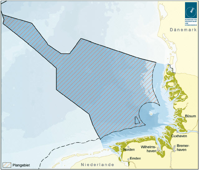
In the case of the exclusive economic zone of the Federal Republic of Germany in the North Sea, the objectives and principles of regional planning are set out in terms of economic and scientific use, in terms of ensuring security, and The lightness of maritime transport and the protection of the marine environment, as set out in the annex to this Regulation, as a spatial planning plan consisting of a text part and a card part.
1) 2)
Unofficial table of contents
§ 2 Entry into force
This Regulation shall enter into force on the day following the date of delivery.
Unofficial table of contents
Annex (to § 1)
Spatial planning plan for the German exclusive economic zone in the North Sea
(text part and card part)
(Fundstelle: Investment country for BGBl. I 2009, No 61, p. 3107 of 25 September 2009, p. 1-34, separate map)
Spatial planning plan
for the German exclusive
Economic zone in the North Sea
-Text Part-
table of contents
-
1.
-
Introduction
-
2.
-
Guidelines on the spatial development of the EEZ
-
2.1
-
Securing and strengthening shipping
-
2.2
-
Strengthening economic power through orderly spatial development and optimization of land use
-
2.3
-
Promotion of offshore wind energy use according to the German government's sustainability strategy
-
2.4
-
Long-term protection and use of the special properties and potentials of the EEZ through the reversibility of uses, economical land use and priority for sea-specific uses
-
2.5
-
Safeguarding the natural resources of life through the prevention of disruptions and pollution of the marine environment
-
3.
-
Provisions of the spatial planning plan
-
3.1
-
Shipping
-
3.1.1
-
Objectives and principles
-
3.1.2
-
Justification
-
3.2
-
Raw materials extraction
-
3.2.1
-
Objectives and principles
-
3.2.2
-
Justification
-
3.3
-
Piping and submarine cables
-
3.3.1
-
Objectives and principles
-
3.3.2
-
Justification
-
3.4
-
Scientific marine research
-
3.4.1
-
Principles
-
3.4.2
-
Justification
-
3.5
-
Energy production, in particular wind energy
-
3.5.1
-
Objectives and principles
-
3.5.2
-
Justification
-
3.6
-
Fisheries and Mariculture
-
3.6.1
-
Principles
-
3.6.2
-
Justification
-
3.7
-
Marine environment
-
3.7.1
-
Principles
-
3.7.2
-
Justification
-
4.
-
Consideration of other concerns
-
4.1
-
Military use
-
4.2
-
Leisure and Tourism
-
4.3
-
Munitions countersunk areas and sediment introduction
-
5.
-
Summary environmental statement and presentation of the measures to monitor the significant environmental impacts
-
5.1
-
Summary environmental statement in accordance with § 7 paragraph 8 sentence 2 ROG 1998
-
5.2
-
Surveillance measures in accordance with § 7 paragraph 8 sentence 3 ROG 1998
-
6.
-
Coordinate Overview and Transnational Lines
-
6.1
-
Coordinate Summary
-
6.1.1
-
Shipping
-
6.1.2
-
Piping and submarine cables
-
6.1.3
-
Research
-
6.1.4
-
Wind energy
-
6.2
-
Transnational pipelines in the North Sea
-
1.
-
Introduction
In order to coordinate the increasing conflicts of use on the sea, in particular between the developing area-intensive offshore wind energy use and the marine environment protection as well as the traditional uses such as shipping and fishing The development of the German exclusive economic zone (EEZ) requires a view to be integrated in the sense of sustainability. In accordance with § 18a of the Spatial Planning Act, which was inserted in the Law of 24 June 2004 in the Law on Spatial Planning, the spatial planning plan set up as a legal regulation lays down the objectives and principles of spatial planning in the EEZ for the first time with regard to the spatial planning law. economic and scientific use, in terms of ensuring the safety and lightness of maritime navigation and the protection of the marine environment. Note: The basis for authorisation is § 18a of the Spatial Planning Act of 18 August 1997 (BGBl. 2081, 2102), as defined by Article 10 (2) of the Law of 9 December 2006 (BGBl). 2833)-the following: ROG 1998. According to § 29 paragraph 1 sentence 1 ROG of 22 December 2008 (BGBl. 2986)-hereinafter 'ROG'-will continue to apply in the case of procedures for drawing up spatial planning plans formally launched before 31 December 2008, § 18a ROG 1998. This is the case in the case of the present legal regulation, since the proceedings were formally initiated at the latest with the first disclosure of the draft plan in the context of public and public participation in June 2008. In the spatial planning plan, the requirements of the new ROG for better readability are provided in each case as a staple supplement. In the spatial development plan guidelines for spatial development are formulated (Chapter 2) and objectives and objectives and Principles, in particular areas, for functions and uses (Chapter 3). The spatial planning plan for the German EEZ in the North Sea meets coordinated stipulations for the individual uses and functions of shipping, raw material extraction, piping and submarine cables, scientific marine research, wind energy generation, Fisheries and Mariculture, as well as the protection of the marine environment. Which other concerns are taken into account is set out in Chapter 4. Chapter 5 explains how to deal with the results of the environmental report. Chapter 6 provides a map of coordinates on the definitions and representations of the transnational pipelines in the North Sea. The territorial definitions for offshore wind energy are used for the implementation of the " Strategy of the Federal Government for the Wind energy use at sea " from 2002 as part of the sustainability strategy, in order to create the framework conditions for the development of the potential of offshore wind energy. The Federal Government's Integrated Energy and Climate Programme (IEKP) of December 2007 also formulates the goal of increasing the share of renewable energy in electricity generation. The spatial planning plan also contributes to the implementation of the National Strategy for the Sustainable Use and Protection of the seas (National Marine Strategy) of 1. The aim of the programme was to provide the Federal Government with a sustainable development and a better balance of interests and protection, as well as to the development of coastal and maritime spatial planning as an important instrument for the development of the In accordance with § 7 (5) of the ROG 1998 (see below), the development of this spatial planning plan is to be carried out in accordance with the provisions of § 9 ROG) accompanying and/or integrates an environmental assessment of the plan (so-called "Strategic Environmental Assessment") in accordance with the requirements of Directive 2001 /42/EC of the European Parliament and of the Council of 27 June 2001 on the assessment of the effects of certain plans on the environment; and programmes (OJ C 327, 30) (the SEA Directive). The aim of the SEA Directive is to ensure a high level of environmental protection with a view to promoting sustainable development and to contribute to environmental considerations in the preparation and adoption of plans, and programmes shall be included in order to ensure that certain plans and programmes likely to have significant effects on the environment are subject to an environmental assessment in accordance with this Directive. " The provisions of the spatial planning plan (see Chapter 3) have been taken in the light of the results of the Strategic Environmental Assessment (see Chapter 5). Schleswig-Holstein has been taken into account for the territorial sea. The Regulation of the Land-Spatial Planning Programme of Lower Saxony, as amended by the Notice of 8 May 2008 (Nds. GVBl. 2008, p. 132) meets the requirements of the coastal sea for wind energy and nature conservation as well as for the derivation of the electricity generated on the sea and for maritime navigation. The statements of the Land Schleswig-Holstein Land and Sea Regional Planning Report of January 2006 were also taken into account. At present, the Schleswig-Holstein Land Development Plan 2009 is in a new position to make statements on the territorial sea of Schleswig-Holstein. The final position of the point E0 (53 ° 43 '30,8 "N; 6 ° 20' 49,7" E) of the side The demarcation of the exclusive economic zone of the Federal Republic of Germany to the Kingdom of the Netherlands, as well as the demarcation of the country towards this point, will be decided by the Federal Government after consultations at a later date; cf. Proclamation of the Federal Republic of Germany on the establishment of an exclusive economic zone of the Federal Republic of Germany in the North Sea and in the Baltic Sea of 25 November 1994 (BGBl. 1994 II p. 3769, 3770).
-
2.
-
Guidelines on the spatial development of the EEZ
Against the background of the guiding principles of sustainable spatial development and the relevant principles of the Spatial Planning Act, the spatial development of the EEZ is to be aligned with the following guidelines.
-
2.1
-
Securing and strengthening shipping
The Federal Republic of Germany is one of the leading export nations, with a large part of the exported goods being transported by sea. In addition, according to the 2007 Annual Report of the Fleet Command, the maritime economy in Germany represents a significant industry with around 500 000 direct and indirect employees and a turnover of more than 54 billion euros. In addition, the North Sea and the Baltic Sea are of great importance for international transit shipping. Shipping lanes off the German coasts-especially the Baltic Sea-are already among the world's most busiest, a further increase is forecast. Dynamic development is also predicted for the German seaports. For example, the 2025 maritime traffic forecast, drawn up on behalf of the Federal Ministry of Transport, Building and Urban Development (BMVBS), assumes that the envelope will more than double in the German seaports by 2025. Against this background, there is a great national and international interest in restricting maritime transport as little as possible, giving priority to it where possible, and making it as safe as possible. At the same time, the United Nations Convention on the Law of the Sea of 10 December 1982 (BGBl. 1798, 1799) (SeeRübk), a special position on shipping, guaranteeing their freedom and giving priority to the main shipping routes. Artificial islands, installations and structures and the surrounding safety zones shall not be established where this may impede the use of recognised and important shipping lanes for international shipping (see Chapter 3.1.2). The scope of regional planning is to express this economic importance and the primacy of international law as well as to maintain the competitiveness of the maritime economy. Thus, the main shipping routes, which are composed of the traffic separation areas (VTG) as well as other busy routes, form the basic framework for the overall planning. The other uses in the EEZ have to be guided by this. This approach contributes to increasing safety and lightness in maritime transport by minimising barrier effects on shipping.
-
2.2
-
Strengthening economic power through orderly spatial development and optimization of land use
The introduction of a spatial planning in the EEZ of the North Sea makes it possible, if necessary, to to look at and coordinate competing uses in an overall show and thus to create a balance of interests. This is an orderly spatial development in the AWZ.This orderly spatial development is an important basis for the future economic development and takes into account the importance of the indigenous raw materials sand, gravel and Hydrocarbons and fisheries. The investment security is all the higher, the further the different usage entitlements are coordinated with each other and each use will be given sufficient space for development. Furthermore, an optimization of the land use ensures that the uses are realized only at the most suitable locations without having a negative influence on other uses, which in turn provides the basis for a higher added value. .
-
2.3
-
Promotion of offshore wind energy use according to the German government's sustainability strategy
One basis of the spatial planning plan is the "Strategy of the Federal Government on the Use of Wind Energy at Sea" of January 2002 within the framework of the Sustainability Strategy. The Federal Government has set itself the goal of creating the framework conditions for the rapid development of the potentials of offshore wind energy. In addition to other measures, the aim is to reduce the dependence on imports in the field of energy production and to further improve the environmental compatibility, especially with regard to climate protection aspects. In this strategy, the installation of 2 000 to 3 000 megawatts (MW) of power and, by 2030, the installation of a total of 20 000 to 25 000 MW of offshore wind power (coastal seas and EEZ of the North Sea and the Baltic Sea as a whole). This strategy is intended to make an important contribution, the objectives of the Renewable Energy Act of 25. October 2008 (BGBl. I p. 2074) (EEG). Against this background, the establishment of three special suitability areas for wind energy in accordance with Section 3a of the Maritime Act of 23 January 1997 (BGBl) was carried out by 31 December 2005. 57) (SeeAnlV) (see Chapter 3.5). Against the background of the Federal Government's Integrated Energy and Climate Programme (IEKP) of December 2007, Section 1 (2) of the EEG stipulates that by 2020, the share of the Renewable energies at the power supply should be at least 30 percent, and then continuously increased. According to the IEKP, offshore wind energy in the coastal sea and in the EEZ will contribute significantly (up to 25,000 MW up to 2030). Both the sustainability strategy of 2002 and the IEKP from 2007 are the basis of the Spatial planning plan. In the case of the special aptitude areas according to § 3a SeeAnlV, a special suitability of these areas for the use of wind power generation could be determined even at the level of the spatial planning after the inclusion of further concerns and final consideration. According to § 3a SeeAnlV, as stipulated in § 18a Paragraph 3 of the ROG 1998, these special aptitude areas are now taken over as targets of regional planning and are defined as pre-eminent areas. This gives investors further planning security in offshore wind energy. In addition, in order to promote the use of offshore wind energy, further suburb areas are established at appropriate locations (see Chapter 3.5) and regulations for the derivation of the electricity generated in the EEZ (see Chapter 3.3). In this way, the spatial planning plan AWZ is intended to make an important contribution to the implementation of the decisions of the Federal Government to promote the use of wind energy at sea (see Chapter 3.5). the maritime economy and the wind industry have expressed the expectation that by the end of 2011 Offshore wind farms with a performance of approx. 1 500 MW in construction or Operation will go.
-
2.4
-
Long-term protection and use of the special properties and potentials of the EEZ through the reversibility of uses, economical land use and priority for sea-specific uses
The sea is a special planning and living space, which is characterized in particular by expanse, openness and accessibility. Spatial planning shall ensure that the arrangement and design of uses do not preclude the maintenance of these properties. In addition, the special three-dimensionality of the sea must be taken into account. Sea surface, water column, seabed, seabed, and airspace may be subject to different protection requirements and use claims. The guideline is that fixed uses must be reversible, d. h. may only take place temporarily and temporarily. This requirement is in line with national and international regulations, according to which construction and technical installations are to be dismantled according to the task of the use. In addition, the long-term protection and use of the potential of the EEZ is to be aimed at a more economical use of surfaces. This also corresponds to the guiding principle of sustainable spatial development. By concentrating the territorial definitions on certain areas, it will be possible to keep large parts of the sea free from fixed building and to reduce cutting effects. By reducing the need for space, it is possible to make an important contribution to the protection and preservation of characteristic natural spaces. In addition, in the use of areas in the case of suitable constellations in the sense of a sparse Use of space to make multiple use of space. In the case of multiple use, it is necessary to ensure that the priority use is not affected. In certain cases, for example, wind energy use as well as oil and gas extraction at some locations can be realized at the same time without conflict. This also takes into account the special characteristics of the three-dimensionality of the sea, so that, for example, different uses for the seabed and the sea surface can be regulated. Furthermore, it must not be a shift of the problems coming from the country to the sea. It must be avoided that there is a collection of uses on the sea, which are undesirable in the country. Uses that depend on the sea should have priority over other uses.
-
2.5
-
Safeguarding the natural resources of life through the prevention of disruptions and pollution of the marine environment
In order to safeguard the natural resources of life in responsibility for future generations, the aim is to ensure the conservation, protection and promotion of natural functions, systems and processes. Disturbances and pollution of the marine ecosystem and the natural functions, systems and processes related thereto must be avoided; the biological diversity must be promoted and preserved. in a national and international context. In order to do justice to this circumstance, it is the task of spatial planning to secure natural spaces and to minimize further impairments of the marine environment. Since the effects of human interventions in the natural habitats on the sea have so far only been incompletely known, the precautionary principle is of particular importance in the EEZ, especially since the susceptibility to disturbance in this natural environment is The high dynamics of the sea are particularly high. It is therefore desirable to use the space as gently as possible. This also includes the fact that each use should be designed to be as natural as possible and according to the current state of the art. In order to protect the marine environment within the framework of a source-based approach to different uses, it is established that the damage or destruction of sand banks, reefs and the areas of delinquent areas with protection To avoid benthic communities as particularly sensitive habitats. This also applies outside of Natura 2000 sites. The protection of the marine environment includes in particular the flora and fauna of the sea, including their habitats and habitats, as well as bird migration. The regenerative capacity and the sustainable use of natural goods are to be secured in the long term. The quality of the sea water, the hydrography and the sediment conditions are also to be attributed to the marine environment. The spatial planning plan for the North Sea EEZ also makes a contribution to the implementation of Directive 2008 /56/EC of the European Parliament and of the Council of 17 June 2008 establishing a framework for Community action in the field of the marine environment (OJ L 136, 31.7.2008, p. 19) (Marine Strategy Framework Directive), which provides the framework for achieving or maintaining a good state of the marine environment at the latest by 2020.
-
3.
-
Provisions of the spatial planning plan
Priority areas shall be laid down for the use of navigation, piping and submarine cables and wind energy, where other uses are excluded, provided that they are not compatible with the priority uses. The territorial definitions for shipping and for piping and submarine cables shall take account of the principle of international law of the supremacy of these uses, and shall constitute shipping lanes which are recognised and important for international shipping. the basic framework for the overall planning. Reserved areas are defined for the uses of navigation, piping and research, which are attached to particular weight in consideration of competing spacial uses. The objectives of spatial planning are to be defined by bold text highlighted and additionally marked with (Z).
-
3.1
-
Shipping
-
3.1.1
-
Objectives and principles
| (1) |
In the designated priority areas for navigation presented in the map, priority shall be given to shipping over other space-related uses. To the extent that spatial planning, measures and projects in these areas are not compatible with the function of the priority area of shipping, these are excluded. (Z) |
Priority areas
Shipping |
| (2) |
In the reserved areas for shipping represented in the map, a particular weight is attached to the shipping. This is to be adjusted in the course of consideration with other spatial planning, measures and projects in accordance with the benefit of shipping. |
Reserved areas
Shipping |
| (3) |
The burden on the marine environment by shipping is to be reduced. In addition to the relevant provisions of the International Maritime Organization (IMO), the best environmental practice is to be established in accordance with the Convention on the Protection of the Marine Environment of the North Atlantic of 22 September 1992. (OSPAR Convention) as well as the state of the art. |
Protection of
Marine environment |
-
3.1.2
-
Justification
Legal background The legal situation of shipping is strongly influenced by international regulations. In particular, the law on the United Nations Convention on the Law of the Sea of 10 December 1982, in which freedom of navigation is guaranteed in accordance with Article 58, is to be mentioned. Moreover, Article 60 (7) of the SeeRexercise stipulates that artificial islands, installations and structures and the security zones surrounding them must not be established where this is more important for the use of recognised and for international shipping. In addition, IMO international rules and standards are laid down. For spatial planning, the definition of traffic areas is of particular importance. At potential danger points, they establish a binding route in the interior of the furnishing traffic with separate lanes.
-
-
-
The Maritime Task Act, as amended by the Notice of 26 July 2002 (BGBl. 2876) (SeeAufgG), and in particular the various regulations adopted pursuant to this Act, provide the legal basis for measures to prevent risks to the safety and ease of transport, and to prevent the risks associated with the prevention of risks to the safety and safety of the environment. Maritime transport risks including harmful environmental impacts.
The SeeAufG is also valid in the EEZ as far as is legally permissible under international law. |
To (1) and (2): The shipping has a special position in the EEZ according to the SeeRübk and enjoys the freedom guaranteed under Article 58 of the SeeRübk. Accordingly, shipping is, in principle, possible everywhere, even outside the territorial provisions laid down for them. The territorial definitions do not justify new shipping routes. This would be the sole responsibility of the IMO. The spatial planning of shipping is particularly useful for the additional space-based safety of basic nautical requirements in the area of important routes. Any further requirements (nautical required extension of shipping lanes/manoeuvring space, etc.) remain unaffected and are perceived by the competent authorities. The provisions of priority and reserve areas for the Shipping is the result of a comprehensive spatial planning consideration. Therefore, since the provisions are based not only on nautical considerations-which, however, are the main aspects-they can be used by the actual shipping routes and the navigational and/or navigational routes required from the nautical point of view. Safety rooms devid.Starting points for the definition of a differentiated system of priority and reserved areas for navigation were in particular the VTG as well as the main shipping routes, which were based on an evaluation of the current Traffic flows are based. The priority and reserved areas for shipping have been-where necessary-adapted in part from the current traffic to planned construction sites. The breadth of the defined areas is oriented in particular to the needs the spatial basic security of a route network for shipping. Nautical considerations are an important concern here. The priority areas are the basic framework, which is to be kept free of all incompatible uses, in particular of high-rise buildings. In addition, conditional areas are also defined, in which a particular weight is attached to the concerns of shipping in the balance, in particular with regard to the construction of fixed installations. As the shipping in the EEZ is the In accordance with Article 58 of the SeeRübk, guaranteed freedom, the definition of priority areas, in particular in the area of VTG, is an additional space-based protection of the interests of shipping. Article 60 (7) of the SeeRexercise stipulates that artificial islands, installations and structures and the safety zones surrounding them must not be established where this is more important for the use of recognised and for international shipping. Obstructing shipping lanes. In the case of the main shipping routes outside the VTG, it is ensured that these areas are kept free of unbearable uses for shipping-in particular of structural installations-so that these areas are kept free of any kind of land. the effect of Article 60 (7) of the SeeRübk shall be achieved. The establishment of safety zones up to 500 m in installations according to § 7 of the SeeAnlV to ensure the safety of navigation as well as the installations will be rejected. The safety and lightness of the shipping industry will thus also be used for the future planned, which means that shipping can use all the regular routes as smoothly as possible and without complications. On the basis of the special status of shipping according to SeeRübk, as well as the comprehensible demarcation of the territorial definitions, the provisions of the spatial planning plan do not lead to any new adverse effects on military operations. Usage.
-
-
-
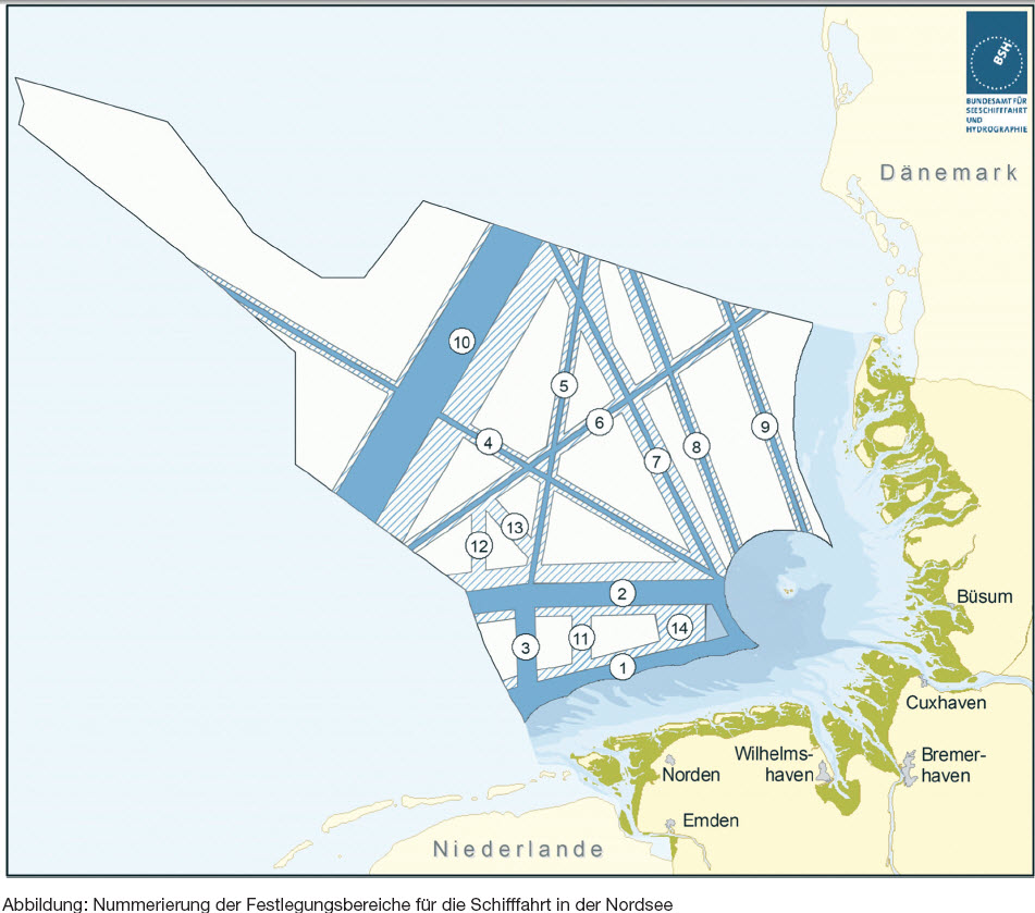
Priority areas: The VTG Terschelling German Bight and German Bight Western Approach have been defined in their entire width as priority areas (defining areas Nos. 1 and 2, see Fig.). In addition, the main shipping routes identified from a traffic point of view have been fixed at a width of 1 naun mile (1 nautic mile (sm) equivalent to 1.852 km) (No. 4 to 9). These territorial definitions define the basic framework for shipping, which must be kept free of unbearable uses, in particular of building installations. The width of 1 sm is based on the double safe passage distance of two ships, which, according to the Water and Shipping Directorate North on the high seas, is 0.5 nm. Since these routes are of mind. ca. 1 000 to max. ca. 4 900 vehicles per year-which, in the last case, represents an average of 13 vessels per day-is considered to be sufficient for basic safety.
-
An exception is the route which represents the extension of the route between the VTG in the Dutch area (no. 10). The route is in contrast to the other main shipping routes outside of the VTG with approx. More than 30 200 vehicles per year are much more heavily driven. Against this background, a suburb with a width of 10 sm was established here. The width is based on the width of the VTG in front of the East Frisian coast (no. 1 and 2), which, including safety distances, likewise amounts to approximately 10 sm. In order to take into account the fact that there is a wider dispersion of traffic volumes in the open sea space than in the VTG, the overall width is secured here as a prima face. The exact location of the suburb is due to the danger potential, in particular from the increased emergence of tankers in and from the Dutch VTG.
-
The fixing area No. 6 has been selected in such a way that the existing compressor platform H7 is outside of the territorial definitions.
-
The fixing area No. 8 does not correspond to the current traffic flow in this area, but was used in anticipation of expected traffic shifts after the realization of already approved as well as to be expected offshore wind farms in the Adjacent suburb of wind energy.
-
Against this background, the entire remaining area of the Emsan control between the individual fields of the primary area for wind energy "North Borkum" was also defined as the primary area for shipping (setting area No. 3). Due to the expected increase in traffic in this sea area, the nautically required maneuvering room is secured by a priority area and not as in other setting areas by a reserve area. This will take into account the special traffic situation in this marine area, which will be influenced by wind energy plants in the future, which will be used for the Emsan control.
-
It is pointed out that the Kingdom of the Netherlands is pursuing plans to construct a terminal for the handling of liquid natural gas (LNG) in Eemshaven, so that with the transport of LNG carriers the Qatar-Max-Class with approx. 135 tidedependent courses are to be expected in the year on the outside world. Since the entry of these LNG carriers into the external ems can become impossible in the case of unfavorable boundary conditions (wind, tide, view, etc.), the establishment of a suitable seesside area would be possible with the concretization and realization of the LNG terminal as a Anchorage necessary as a manoeuvring space (vapour deposition) which is sufficiently far from the priority areas of wind energy and shipping. The area will be displayed in the map of the spatial planning plan.
-
-
-
Reserved areas: In order to further secure the basic framework for navigation, the ship journey is accompanied by accompanying and supplementary reserved areas. The aim is to provide additional rooms with a priority for shipping, for example: B. to give enough space to maneuver. The following reserve areas have been defined in the North Sea:
-
-
-
Along the VTG off the East Frisian coast (No. 1 and 2), a double-sided safety distance of 2 sm is defined as the nautical required maneuvering space. This is necessary in order to ensure sufficient traffic space for multi-nave encounters and overtaking operations. The reservation area north of the shipping route no. 2 (German Bight Western Approach) is set to a width of 3.5 sm, since for this VTG for certain tank and dangerous goods ships of 5 000 or more, respectively. 10 000 GRT (approx. 1 900 vehicles per year, corresponding to approx. 50 per cent of all vessel movements subject to reporting requirements) are subject to a user obligation. For the vehicles that do not use the VTG, sufficient maneuvering room is required. This concerns approx. 1 000 vehicles per year, which are currently operating in the area of land transport. In the construction of the north-lying suburb for wind energy "East Austerngrund" as well as in the construction of other approved offshore wind farms located outside the priority area, the transfer of traffic from the wind farm will be Area, which can then no longer be driven, the concentration effect on the remaining areas even further reinforced.
-
-
-
Along the main shipping routes nos. 4 to 10, reserve areas are fixed on both sides. As a rule, these have a width of 1 sm, in accordance with the dimensioning of the suburb regions. There are the following exceptions: for the route Elbe, Weser, Jade-Norway/Scandinavia (no. 7) on the basis of the higher traffic volume of this main shipping route, the double width of 2 sm each for the reserved areas is estimated. In addition, in the northern part of Route 8, between approved wind farm projects, the reserve area on the west side of the route is set at a width of 2 nm. On the east side, the width is 1 sm. The aim of this definition is to ensure that, due to the expected changes in traffic, the implementation of the already approved wind farm project between routes 7 and 8 will result in the implementation of a VTG in order to ensure a safe and secure environment. Shipping is possible. The same applies to the reserve area in the northeastern crossing area of routes 5 and 7, which is brought up to the approved project areas of the offshore wind farms up to a distance of 1 700 m.
-
Another exception is the route, which represents the extension of the route between the VTG in the Dutch area (no. 10). Since the route, in contrast to the other main shipping routes located outside VTG, with approx. 30 200 vehicles per year are much more heavily driven and there is a comparatively high traffic volume to the east of the pre-defined area, a reservation area of 6.5 sm width is set in the area.
-
-
-
In order to avoid a locking effect of offshore wind energy parks for shipping, in areas where the current state of knowledge has to be reckoned with a compressed construction of offshore wind energy parks-in particular along the Priority areas for wind energy-reserve areas for shipping (No 11 to 13). These are dimensioned in accordance with the other shipping routes (1 sm suburb area plus 2 x 1 sm reserve area) with a width of 3 sm. The reserve area No. 13 is slightly wider, since it is oriented towards the adjacent two reserve areas for pipelines and fills the area between them in full.
-
-
-
West of the deep-water talk (No. 14), a reservation area is established as far as the Europipe 2, in order to secure sufficient navigation area here. This area is used, in particular, by anchor lieders in the case of storms from the southwest to the northwest. Due to the surrounding VTG, manoeuvring vehicles only have the option of running to the west. In addition, depending on the future traffic development-especially after the realization of the Jade-Weser-Ports in Wilhelmshaven-where applicable with an expansion of deep-water talk to the west.
To (3): International agreements to prevent damage to the marine environment, such as the International Convention for the Prevention of Pollution from Ships of 2 November 1973 (BGBl I). 2, 4) in the version of the Protocol of 17 February 1978 (BGBl. 2, 24) (MARPOL) and the Convention on the Protection of the Marine Environment of the North-East Atlantic of 22 September 1992 (BGBl I). 1355, 1360) (OSPAR Convention), the aim is to ensure that shipping is as low as possible in the marine environment. In addition to the binding regulations of the IMO, the best environmental practice ("best environmental practice") should be taken into account in accordance with the OSPAR Convention as well as the state of the art in each case.
Figure: Numbering of fishing areas for shipping in the North Sea
-
3.2
-
Raw materials extraction
-
3.2.1
-
Objectives and principles
| (1) |
The search for and extraction of raw materials is to be made possible and developed in full compliance with the specialist law. |
Basic |
| (2) |
In order to safeguard future needs in the long term, knowledge of raw material resources-especially hydrocarbons-should be systematically and permanently documented and evaluated by the relevant specialist authorities. |
Continuous
Documentation |
| (3) |
According to the task of the use, construction plants for the extraction of raw materials are to be built back. (Z) |
Decommissioning |
| (4) |
The aim is to achieve the greatest possible area-saving and concentrated extraction of raw material deposits. Existing extraction points for sand and gravel are to be dismantled as fully as possible, to the extent that it is compatible with the requirements of the marine environment and with the maintenance of a residual sediment layer required for the regeneration of communities, and the extension of which will be brought forward to an indication of new deposits. |
Concentration
the extraction |
| (5) |
The aim of the search for and profits of raw materials is to ensure that the safety and ease of transport are not affected. |
Transport |
| (6) |
In the case of measures for the extraction of raw materials, due consideration must be given to existing pipelines and submarine cables and must be kept at an appropriate distance. (Z) |
Pipelines and
Sea Cable |
| (7) |
In the event of a simultaneous use of land by the search for and extraction of raw materials as well as the use of wind energy, the best possible coordination of the issues is to be carried out in accordance with the conditions laid down by the competent authorities. To aim for criteria. |
Wind energy |
| (8) |
The interests of fisheries should be taken into account in the search and extraction of raw materials. |
Fisheries |
| (9) |
Adverse effects on the marine environment, in particular the natural functions and the ecosystem importance of the sea, are to be avoided through the search for and extraction of raw materials. The best environmental practice ("best environmental practice") according to the OSPAR Convention and the state of the art should be taken into account.
The effects of the extraction of raw materials on the marine environment are to be investigated and set out in the context of a project-related monitoring according to the requirements of the approval authority. Propagation processes and long-range ecological interactions of animal and plant species in the sea are to be taken into account in the choice of the location for the extraction of raw materials. The damage to or destruction of sand banks, reefs and demarcable areas with the presence of worthy Benthol communities as particularly sensitive habitats is to be avoided in the extraction of raw materials. |
Protection of
Marine environment |
| (10) |
The site selection for the extraction of raw materials is intended to take into account known sites of cultural heritage. If no known cultural objects are found in the seabed in the search for or extraction of raw materials, appropriate measures are to be taken to ensure the preservation of the cultural heritage. |
Cultural goods |
-
3.2.2
-
Justification
| Legal background The exploration, protection and demand-oriented development of the raw material resources in the German EEZ is of great importance for the common good and important basis for the future economic development of Germany. This circumstance is also borne by the Commodity Safeguard Clause of Section 48 (1) sentence 2 of the Federal Mining Act of 13 August 1980 (BGBl. I p. 1310) (BBergG). This means that the non-compliance rules are to be applied by the other competent authorities in such a way that the search for and extraction of raw materials is impaired as little as possible. There are differentiated regulations in § § 48 et seq. BBergG, which is responsible for the shipping, fishing, laying and operation of cables and pipelines and the marine environment at the time of the search, respectively. Approval of operating plans for a plant in the area of the continental shelf must be observed. Since the use has been taking place in the sea for a long time, there is already a relatively high stock of granted in the area of raw material extraction. Mining permissions. It is necessary to distinguish between permits and permits. In accordance with § 7 of the German Federal Mining Act (BBergG), permission is granted, in particular, to grant the exclusive right to search for natural resources in a certain field. In accordance with § 8 of the German Federal Law on the Law of the Federal States, the authorization grants, in particular, the exclusive right to obtain the raw material Failure to grant permission or the authorization shall be determined in accordance with § 11 or § 12 BBergG. If raw materials are found during the search, the authorization pursuant to Section 12 (2) of the German Federal Law on the Law of BBergG may only be denied if one of the reasons listed in § 12 paragraph 1 BBergG exists for this and the facts which justify the failure of the search shall not be after the granting of the permit. The Landesamt für Bergbau, Energie und Geologie Clausthal-Zellerfeld (North Sea as well as the Baltic Sea in the Schleswig-Holstein region) is responsible for mining rights. the Bergamt Stralsund (Baltic Sea in the area of Mecklenburg-Western Pomerania). Consists of the Ordinary on the Environmental Impact Assessment of Mining Projects of 13 July 1990 (BGBl. 1420) (UVP-V Mining), an obligation to carry out an environmental impact assessment for the planned activity, a framework operating plan shall be drawn up and a plan setting procedure shall be established, including: Environmental impact assessment (EIA) (§ 52 (2a) BBergG). This is the case, for example, in the construction and operation of conveying platforms as well as in the case of extensive sand and gravel extraction (as of 10 ha). For all plants which are used in the course of the raw material search and/or According to Article 55 (2) of the German Federal Mining Act (BBergG), there is a rebuilding obligation on the part of the use of the building. Further regulations apply to the Mining Ordinance for the Continental Shelf of 21 March 1989 (BGBl. I p. 554) (Festlandsockel-Bergverordnung-FlsBergV). Beyond the technical regulations, the principles of regional planning stipulate that for the preventative protection as well as the orderly search and extraction of site-based raw materials, the spatial conditions (Section 2, paragraph 2, point 9 of the ROG 1998; cf. Article 2 (2) (4) of the ROG). to the Communication from the Commission to the European Parliament and the Council of 4 November 2008 entitled 'Raw Materials Initiative-ensuring Europe's supply of goods needed for growth and employment' (COM (2008) 699) is pointed out. |
To (1): raw materials such as sand, gravel and hydrocarbons are a valuable economic good. Their extraction takes place on the sea with special site conditions which are not comparable to those on land. From a space-based perspective, land is available in the EEZ for the search and extraction of raw materials on a large scale. The exploration and extraction of raw materials is to be made possible and developed in full compliance with the law of the field (Bergrecht, environmental and nature conservation law). (2): The raw material resources in the EEZ-in particular those of hydrocarbons- are currently being researched only in an approach. Various search activities take place in a wide variety of open-air fields. The knowledge gained here is to be documented and evaluated systematically and permanently by the competent authorities responsible for this. Only in the case of sufficient knowledge can the spatial planning develop its full control power. To secure areas for raw material extraction-d. h. In particular, the release of uses, which could be countered by subsequent extraction, requires a resilient knowledge of raw material resources. These can then be the basis for a future continuation of the spatial planning plan and, moreover, for a long-term and sustainable safeguarding of the resources resources in the interest of future generations. In this context, the project Geopotential German North Sea is to be found. (3): According to the spatial guideline, that fixed uses must be reversible, d. h. may only take place temporarily and temporally limited, construction equipment in connection with the promotion of raw materials after abandonation of the use shall be built back. This definition is in accordance with the relevant international and national regulations, such as Article 60 (3) of the SeeRübk, the IMO resolution on offshore installations, § 55 (2) of the Federal Mining Act (BBergG), § 29 FlsbergV and OSPAR Decision 98/3 on Disposal of off-farm offshore installations (BGBl. 1999 II p. 618, 619). Accordingly, the disposal by sinking (dumping) and the complete or partial withdrawal from the operation of offshore installations for the exploration or extraction of hydrocarbons is prohibited in principle, so that one of the Specifications for the decommissioning of piping and sea cables or Wind power plants are formulated to deviate from the target. The arrangement as well as the design of the back-building in individual cases are the responsibility of the competent specialist authorities. (4): The extraction of raw materials in the sea is generally more extensive than on land, so the potential for conflict with other uses is also relatively high. In addition, mineral resources are limited, fixed and non-replicable. For this reason, the extraction of raw materials should be as sparingly and as concentrated as possible. The raw materials sand and gravel of a deposit should be obtained as fully as possible, insofar as it is necessary to cover the marine environment and to maintain a residual sediment layer required for the regeneration of communities. is compatible. In this way, unavoidable impairments associated with the extraction of raw materials and the development of new deposits can be reduced. This also corresponds to the guiding principle of economical land use (see Chapter 2.4). (5): The safety and ease of transport should not be affected by the search for and profits of raw materials. (6): In order to To reduce the risk of damage to pipelines and sea cables and not to compromise the possibilities of repair, due consideration shall be given to existing pipelines and submarine cables in the case of measures for the extraction of raw materials and a appropriate distance from them. The definition of an appropriate distance must be clarified on a case-by-case basis, as it depends on the specific conditions on the spot, such as: B. the depth of water. This objective is also supported by the determination of reserve areas for pipelines (see Chapter 3.3.1). (7): In the event of a simultaneous use of land by wind energy use and by the search and recovery of Raw materials should be aimed at the best possible coordination of interests. To this end, criteria to be developed and agreed upon by the competent authorities are to be developed and agreed in order to make use of the uses. (8): The fishery is a traditional use of the sea, for which the use of However, it is currently difficult to set up independent space-based definitions (see Chapter 3.6.2). In fisheries where this is not possible due to strong variability in the future, it is therefore necessary to take account of the concerns within the framework of provisions for other uses. This also applies to the extraction of raw materials. To (9): According to the guiding principle for the protection of the marine environment, adverse effects on the natural functions and the ecological importance of the sea should be affected by the search for and the extraction of raw materials is avoided. For further minimisation, best environmental practice should be taken into account in accordance with the OSPAR Convention, as well as the state of the art.
-
In order to ensure that extraction is as environmentally sound as possible, the above-mentioned effects of the extraction of raw materials on the marine environment are to be examined and set out in the context of a monitoring exercise according to the requirements of the approval authority. The targeted monitoring can be regulated by appropriate specifications in the respective approval notices and corresponds to the approval practice of the specialist authorities. The results of the project-related monitoring will be included in the monitoring of the implementation of the spatial planning plan.
-
Section 2, paragraph 2, point 8 of the ROG 1998 (cf. Section 2 (2) (6) of the ROG) combines the protection, the care and the development of nature and landscape with the requirements of a biotope composite system. It is not yet sufficiently researched to what extent the marine ecosystems, which are more and more accessible and accessible, are dependent on habitat-based biotope composite systems to the same extent as terrestrial ecosystems, and how possible building blocks shall be demarcted. Against this background, no detailed definitions are possible according to current knowledge regarding a biotope composite system. However, in choosing the location of raw material extraction, it should be ensured that the propagation processes and the long-range ecological interactions of the species and their habitats are taken into account.
-
The structures referred to in principle 9 are habitats whose damage or destruction is to be avoided even outside the Natura 2000 sites. According to the current state of knowledge, it is possible that the structures mentioned above also occur outside of the reserves in the Natura 2000 sites. However, at this point in time, no specific spatialization is possible. If, however, in the case of more detailed investigations, for example, structures referred to in the specific procedure for the authorisation of raw material recovery should be found, this should be given a special weight in the decision-making process.
Zu (10): In the seabed, cultural objects may be of archaeological value, such as: B. Ground monuments, settlement remains or historic shipwrecks. A large number of such shipwrecks are known and recorded in the underwater database of the Federal Maritime and Hydrographic Agency (BSH). The information available to the competent authorities should be taken into account when determining a winning area. However, it cannot be ruled out that hitherto unknown cultural goods are found in the search for and extraction of raw materials. In order not to damage them, appropriate safeguards are to be carried out in this case in consultation with the competent authority.
-
3.3
-
Piping and submarine cables
-
3.3.1
-
Objectives and principles
| |
Piping |
|
| (1) |
In the specified priority areas for piping as set out in the map, priority shall be given to the operation and maintenance of piping over other spacial uses. Insofar as spatial planning, measures and projects in these areas are not compatible with the function of the priority area pipelines, these are excluded. (Z) |
Priority areas
Piping |
| (2) |
A special weight is attached to the operation as well as the maintenance of pipelines in the defined reserved areas shown in the map. This is to be taken into account in the consideration of other spatial planning, measures and projects. |
Reserved areas
Piping |
| (3) |
In the case of overlays of priority areas for pipelines with priority areas for wind energy, the requirements of the pipelines must be taken into account as a priority. (Z) Piping and submarine cables (incl. Sea cable for the discharge of energy produced in the EEZ) |
Superposition with
Priority areas
for wind energy |
| (4) |
Pre-order areas defined for shipping shall be crossed by sea cues in order to derive the energy produced in the EEZ on the shortest possible path, provided that parallel guidance to existing structures and structures is not possible. (Z) Pre-ranged areas for shipping are to be crossed as far as possible by the shortest route from piping and other sea cables, provided that there is no parallel guidance to existing structural installations. Reserved areas for shipping are to be crossed as far as possible on the shortest possible path, provided that parallel guidance to existing structural installations is not possible. |
Intersection of
Areas for
Shipping |
| (5) |
Piping and submarine cables are to be built back after their use. If the deconstruction causes a greater negative environmental impact than the remaining, it must be completely or partially removed from it, unless the decommissioning is necessary for reasons of safety and ease of transport. (Z) In the event of a stay, appropriate monitoring measures should be taken with regard to possible future risks. |
Decommissioning |
| (6) |
The safety and lightness of the traffic should not be affected by the laying, operation, maintenance and the possible remaining after the operation of the company or by the decommissioning of pipelines and sea cables. The installation of pipelines and sea cables in parallel adjacent to the areas designated for shipping should be avoided. |
Transport |
| (7) |
In the choice of route guidance for pipelines and sea cables, consideration should be given to existing uses and rights of use, protection area expulsions as well as the concerns of the fisheries sector. In the installation of sea cables, the greatest possible bundling is to be sought in the sense of a parallel laying. In addition, the route guidance should be chosen as parallel to existing structures and structures in the case of sea-shanks. Crossing of sea-cables, both with each other and with other existing and planned piping and sea-cables, should be avoided as much as possible. to take due account of new piping and submarine cables; it is appropriate to keep an appropriate distance. (Z) |
Reviewation
on exercised
Use/
existing
Entitlements |
| (8) |
In the installation of piping and marine cables, the species-specific, particularly susceptible time periods should be avoided in order to minimise possible adverse effects on the marine environment in the cross-section of sensitive habitats. Adverse effects on the marine environment the marine environment, in particular the natural functions and the ecosystemic importance of the sea, by laying, operating, maintaining it and by any remaining after the operation of the undertaking or by the decommissioning of pipelines and Sea cables should be avoided. The best environmental practice ("best environmental practice") according to the OSPAR Convention and the state of the art should be taken into account. Propagation processes and long-range ecological interactions of animal and plant species in the sea should be taken into account in the choice of the route of pipelines and sea cables. The damage or destruction of sandbanks, reefs as well as demarcable areas with the presence of vulnerable benthic communities as particularly sensitive habitats should be avoided in the installation and operation of piping and sea cables. |
Limitation of the
Installation Period/Protection
the marine environment ` |
| (9) |
The route selection for the laying of pipelines and sea cables is intended to take account of known sites for cultural goods. If no known cultural objects are found in the seabed in the planning or laying of piping and sea cables, appropriate measures should be taken to ensure the preservation of the crop material. of the energy produced in the EEZ |
Cultural goods |
| (10) |
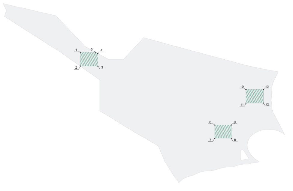
The derivation of the energy obtained in the EEZ to suitable transition points on the boundary to the territorial sea is to be sure. At the transition to the coastal sea and to the crossing of the VTG off the East Frisian coast are sea cables for the derivation in the EEZ through the target corridors identified in the map. The target corridors shall apply to sea cables for the discharge of energy produced in the EEZ in the transitional area to the territorial sea in detail as follows:
-
-
-
with route in the direction of Büsum (Schleswig-Holstein): map section C/North Sea
-
-
-
with route guidance towards Norderney/Hilgenriedersiel (Lower Saxony): map section B/North Sea
The target corridors are valid for the Seekabel for the derivation of energy produced in the EEZ to the crossing of VTG in detail as follows:
-
-
-
on the crossing of the VTG "German Bight Western Approach": map section A/North Sea
-
-
-
to the crossing of the VTG "Terschelling German Bight": map section B/North Sea. (Z)
If the spatial absorption capacity is exhausted in the areas of the respective destination corridors with the above-mentioned routes, the cable configuration for additional cable systems is to be bundled as soon as possible and in coordination with the cable system. The above mentioned target corridors and regulations shall apply in accordance with any other technical solutions to be used for the network connection of offshore wind farms. or, respectively, will be realized. (Z) |
Transition to
Coastal Sea/
Definition of target corridors |
| (11) |
In the case of the laying of sea cables for the discharge of energy produced in the EEZ, the greatest possible bundling in the sense of a parallel guide to one another is to be sought. In addition, the route guidance should be selected as parallel as possible to existing structures and structural installations. Crossings of sea cables for the discharge of energy produced in the EEZ both with each other as well as with other existing and planned piping and sea cables shall be avoided as far as possible. |
Bundling and
Parallel guidance of the
Cable curves/avoidance
of intersections |
| (12) |
The choice of the depth of seabirds for the discharge of energy produced in the EEZ should take into account, in particular, the interests of shipping and fishing and of the protection of the marine environment. |
Laying depths |
| (13) |
To avoid or A reduction of cumulative effects is intended to provide for a total time coordination of the laying work of sea cues for the discharge of energy generated in the EEZ. |
Time
Coordination |
| (14) |
In order to protect the marine environment, it is intended to select a laying method which is as gentle as possible during the laying of sea cables for the discharge of energy produced in the EEZ. |
Laying methods |
-
3.3.2
-
Justification
| Legal background The transfer of submarine cables and pipelines on the continental shelf shall in principle enjoy the freedom granted by Article 58 of the SeeRübk. In accordance with Article 79 (2) of the SeeRübk, the coastal State may not impede the laying or maintenance of such cables or pipelines, subject to its right to take appropriate measures to investigate the continental shelf, to exploit its natural resources and the prevention, reduction and monitoring of pollution by pipelines. The determination of the route for the laying of such pipelines on the continental shelf shall require the consent of the coastal State (Article 79 (3) of the SeeRübk). Furthermore, pursuant to Article 79 (4) of the Maritime Rexercises, the coastal State may lay down conditions for cables or pipelines leading into its territory or its territorial sea, or it may give reasons for its sovereign powers over cables and pipelines which: be built or used in connection with the scientific or economic use of the continental shelf or the EEZ. In addition, Article 79 (5) of the SeeRübk stipulates that the Member States must take due account of existing cables or pipelines when laying down the cables or pipelines. In particular, the possibilities for the repair of existing cables or pipes must not be impaired. With regard to the approval process, a further differentiation of the pipelines and sea cables is necessary. Whereas pipelines and transnational submarine cables are approved in accordance with § 133 of the German Federal Mining Act (BBergG), in the case of sea cables, energy generated in the EEZ is used for "facilities serving other economic purposes", which according to § 1 (2) Number 2, SeeAnlV. For piping, there is a certain length and extent according to the Environmental Impact Assessment Act, as amended by the Notice of 25 June 2005 (BGBl. 1757, 2797) (UVPG) in conjunction with Section 133 (2a) of the German Federal Law Gazette (BBergG), the obligation to carry out a UVP.According to § 17 paragraph 2a of the German Energy Law of 7 July 2005 (BGBl. 1970, 3621) (EnWG), the operators of transmission systems in whose control zone the network connection of offshore installations is to take place, have the lines from the substation of the offshore installations up to the technically and economically most favourable -to establish and operate the linking point of the next transmission or distribution system; the network connections shall be established at the time of production of the technical operational readiness of the offshore installations. From the date of establishment, this management shall be considered as part of the energy supply network. Pursuant to Section 118 (3) of the EnWG, this provision of Section 17 (2a) of the EnWG shall apply only to offshore installations, the establishment of which has been initiated until 31 December 2015. |
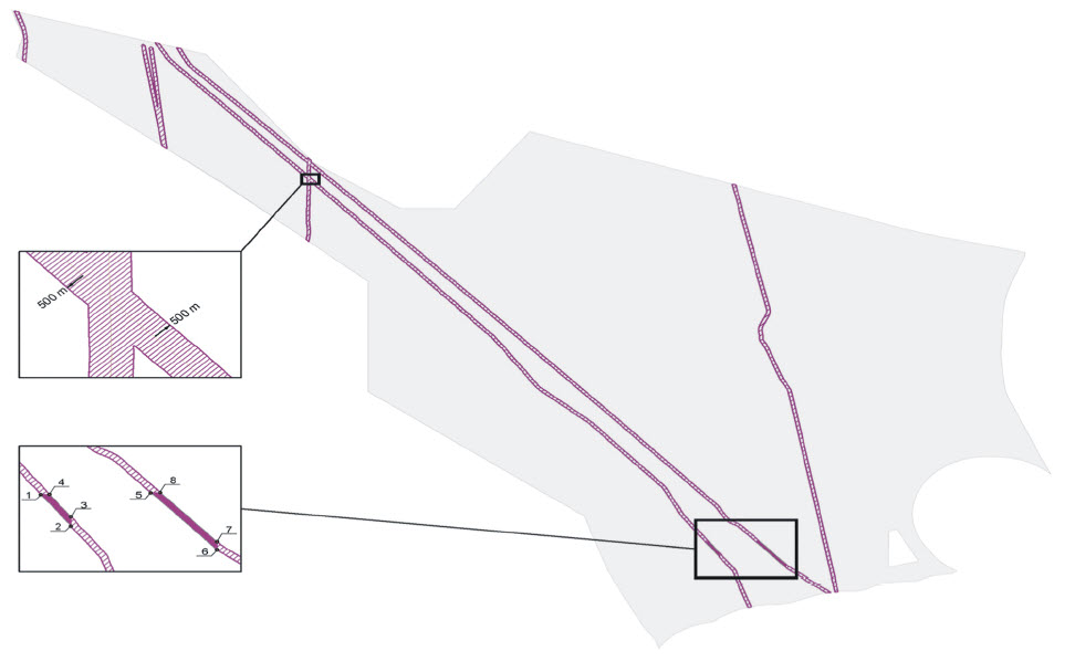
In the case of piping and submarine cables, different specifications are to be found, since the need for regulation is different in parts. This is achieved in particular by the increased control requirement for cables for the discharge of energy generated in the EEZ. Although each individual cable has only a low potential for conflict, the planned expansion of the offshore wind energy also makes it possible to see a corresponding increase in the number of power cables, which triggers a need for regulation. Further spatial arrangements, which minimise the potential for conflict both among themselves and with other uses, and which also ensure an orderly removal of the land-side network, are therefore necessary. In accordance with the division carried out, the lines Nos 1 to 9 are applicable to piping and, for submarine cables, the provisions Nos. 4 to 14, where the provisions Nos 10 to 14 refer to the submarine cables for the discharge of the energy produced in the EEZ. (1): For the protection of existing piping, areas in which existing pipelines pass through priority areas for wind energy are used as priority areas for piping including a double-sided protection distance of 500 m . The needs of the existing pipelines are to be met in order to meet their protection requirements in areas that are only built in the future (see laying down No. 3). Thus, the operation and maintenance of piping can also be secured in pre-ranged areas for wind energy. To (2): Long-term piping is defined as reserve areas including a double-sided protection distance of 500 m. This ensures that other uses take account of the special protection requirements of piping. An exception is the areas in which pipelines pass through priority areas for wind energy, for which priority areas are defined (see laying down point 1). This definition is supported by the provisions of point 7 and the provisions on the use of the appropriate measures to ensure that certain measures take due account of existing piping and submarine cables. (3): Overlays Provisions will be made for pre-treatment areas for pipelines and for wind energy. If there are any conflicting interests here in individual cases, the interests of the existing pipelines will be a priority. The SeeRübk provides a special position for piping through the freedom to transfer under Article 58 (1) of the SeeRübk. In addition, there is a special protection requirement for the needs of the existing pipelines in the area of areas that are only built in the future (see laying down No. 1). This will be taken into account in this definition in combination with specification No 1. (4): In order to minimise the potential for conflict, it is in principle desirable for the most recent possible routes to be crossed for the suburb of the shipping industry. In view of the large number of cable systems to be expected, this is particularly true for the submarine cables used to derive the energy produced in the EEZ, so that a crossing is established on the shortest path as a target, unless a parallel operation is to be carried out. Existing structures and construction facilities are possible. For other submarine cables which do not serve to derive the energy generated in the EEZ, the determination as a target is not currently required. By means of a parallel guide to existing structures, the land use can be reduced. Since, for example, on both sides of a pipeline there is already a ban on anchorage, the additional restriction on shipping is relatively low. The purpose of this objective is to exclude the cables approved at the time of the entry into force of the Spatial Planning Plan pursuant to SeeAnlV, which shall also apply in the case of any extension of such authorisations. Due to different technical conditions (e.g. a. For the crossing of suburb areas for navigation through piping, only one principle is defined for the crossing of the suburb as short as possible. In the light of this, reserve areas for shipping should also be crossed as quickly as possible, provided that parallel guidance to existing structures and structural installations is not possible. The stated objective and the principles move within the framework of the requirements of the SeeRübk.Zu (5): According to the spatial guideline, that fixed uses should be reversible, d. h. As far as possible only temporarily and temporally limited, piping and submarine cables are to be built back to the task of use. The arrangement as well as the design of the back-up in the individual case are the responsibility of the competent specialist authority. In the event that the deconstruction causes a greater negative environmental impact than the remaining, the decommissioning must be completely or partially disregarded, unless the safety and lightness of the traffic require the decommissioning. The decommissioning is also necessary if toxic substances would remain in the marine environment in an impact-relevant way with the pipeline or the marine cable. In the event of a stay, it should also be ensured, in the sense of a subsequent obligation on the part of the operator, by appropriate monitoring measures, that in the future, too, no risks of other uses by the remaining Pipelines or submarine cables are to be expected. For example, the situation and sufficient overlap should be reviewed on a regular basis. This definition is in accordance with international and national rules, and in particular Article 79 (4) of the Maritime Rexercise, according to which the coastal State may lay down conditions for cables or piping to be placed on its territory or territorial sea .
-
Piping and submarine cables (without downstream cables)
-
A decommissioning shall be carried out, in particular, where, as a result of the fate of the pipeline or the sea cable in or on the seabed, at the end of use, there is a risk to the life or health of persons or property, or to a risk to the health of the person or property, or To obtain an impairment of overriding public interests, which cannot be prevented or compensated by a freezing order and by conditions or conditions. This results from the regulations of § 133 paragraph 2 BBergG, which applies to transit pipelines within the meaning of § 4 paragraph 10 BBergG, d. h. on such pipelines which lead from the continental shelf or from the territory of another State to the continental shelf of the Federal Republic of Germany or pass through the latter. However, the underlying valuations can also be transferred to other pipelines and submarine cables.
-
In accordance with Section 132 (2) (3) of the German Federal Mining Act (BBergG), the overriding public interest shall be, in particular,
-
a)
-
the operation and impact of shipping facilities and signs,
-
b)
-
the use of waterways and airspace, shipping, fishing and the world of plants and animals in an unceable manner,
-
c)
-
the laying down, maintenance and operation of other underwater cables and pipelines, as well as oceanographic or other scientific research, would be unavoidably affected by the circumstances,
-
d)
-
to obtain pollution of the sea, or
-
e)
-
the security of the Federal Republic of Germany is at risk.
-
Downstream cables
-
§ 12 SeeAnlV meets a comparable regulation for the downstream cables of offshore wind energy parks. Thereafter, the downstream cables from offshore wind farms must be removed to the extent that they constitute an obstacle to transport or the protection of the marine environment, the requirements of regional planning or other major public transport. Needs to do so. In accordance with Article 12 (2) of the SeeAnlV, the generally accepted international standards for disposal must be taken into account as minimum standards. The decommissioning process is subject to appropriate regulations in the respective admission procedure (e.g. B. as a condition).
To (6): The installation, operation, maintenance and any remaining after the operation of the plant or the decommissioning of pipelines and sea cables shall be carried out in such a way as to ensure that the safety and lightness of the traffic are not shall be affected. This means that the areas defined for shipping will be affected as little as possible. A route parallel to these areas should be avoided. The rules set out in point 4 also serve to reduce the possible disruption of shipping through piping and submarine cables. (7): In the course of conflict minimisation, the choice of route guidance should not be limited to: Pipelines and sea cables are taken into account as early as possible in existing uses/rights of use and property-like rights as well as protection area expulsions (in particular Natura 2000 sites). A route outside these areas should be sought. Consideration should also be given to fisheries issues at an early stage. This is a traditional use of the sea, but it is difficult for the current independent interpretations of the sea to be made (see Chapter 3.6.2). In fisheries where this is not possible due to strong variability in the future, it is therefore necessary to take account of the concerns within the framework of provisions for other uses.
-
In order to minimise the impact on other uses and the need for coordination among themselves as well as with other uses and to create as few compulsions as possible for future uses, sea cables should be bundled as much as possible. In addition, a bundling in the sense of parallel guidance reduces cutting effects. These can be minimized further if a cable guide is selected in parallel with existing structures and existing structural installations. In accordance with the principle of parallel guidance, intersections of both the sea cable with each other as well as with further pipelines and sea cables should be avoided as far as possible. Crossing structures have an increased susceptibility to faults and thus an increased maintenance effort and thus lead in turn to an increased traffic volume by maintenance/repair ships, which is to be avoided.
-
In order to reduce the risk of damage to existing piping and submarine cables and not to interfere with the possibilities of repairing, the choice of route guidance for new piping and submarine cables to existing pipes and cables is already available. to take due account of and to respect a reasonable distance. The definition of an appropriate distance must be clarified on a case-by-case basis, as it is based on the specific conditions on the ground. This objective is also supported by the establishment of priority areas and reserve areas for pipelines (No 1 and 2).
Zu (8): The laying of piping and sea cables leads to unavoidable impairments of different habitats. In order to limit the negative effects on sensitive habitats, laying work is to take place only in periods in which the respective populations are not found in particularly susceptible life phases. The determination of appropriate time periods is the task of the respective specialist authority.
-
In addition, in accordance with the guiding principle for the protection of the marine environment, adverse effects on the natural functions and the ecosystem importance of the sea should be adversely affected by the installation, operation, maintenance and possible Remaining after the operation of the operation or the decommissioning of pipelines and sea cables are avoided. In the event that pipes remain in the sea after the operation of the plant, they are to be emptied of environmentally harmful substances. For further minimisation, the best environmental practice ("best environmental practice") should be taken into account in accordance with the OSPAR Convention and the state of the art.
-
Section 2, paragraph 2, point 8 of the ROG 1998 (cf. Section 2 (2) (6) of the ROG) combines the protection, the care and the development of nature and landscape with the requirements of a biotope composite system. It is not yet sufficiently researched to what extent the more integrated and barrier-free marine ecosystems are dependent on habitat-based biotope composite systems to the same extent as terrestrial ecosystems, and how possible components are to be demarcted. Against this background, according to current knowledge of a biotope composite system, no detailed definitions are possible. However, in choosing the route of pipelines and sea cables, it should be ensured that the propagation processes and the long-range ecological interrelationships of the species and their habitats are taken into account.
-
The structures referred to in this principle are habitats whose damage or destruction is to be avoided even outside the Natura 2000 sites. According to the current state of knowledge, it is possible that named structures may also occur outside of the occurrence in the Natura 2000 sites. However, at this point in time, no specific spatialization is possible. If, however, in the case of more detailed investigations, for example, structures mentioned in the specific procedure for the approval of piping and sea cables are found, these structures must be given a special weight in the decision-making process.
Zu (9): In the seabed, cultural objects may be of archaeological value, such as: B. Ground monuments, settlement remains or historic shipwrecks. A large number of such shipwrecks are known and recorded in the underwater database of the BSH. The information available to the competent authorities should be taken into account when selecting a suitable route for piping and submarine cables. However, it cannot be ruled out that previously unknown cultural goods can be found in the case of a closer examination of a suitable route or in the laying of pipelines and sea cables. In this case, in order not to damage them, appropriate safeguards are to be implemented in consultation with the competent authority. (10): Since cable for the discharge of energy produced in the EEZ, a connection to the land-side power supply system , it is necessary to ensure the guidance of the cables at appropriate transition points on the border with the territorial sea. This is done in accordance with the requirements in the territorial sea, which arise, in particular, from suitable feed points in the high/maximum voltage network on land.
-
In the areas where current knowledge is possible, target corridors will be established in the transitional area to the territorial sea and to the crossing of the traffic areas off the East Frisian coast for the purpose of bundling the sea cues, by which cables to discharge energy produced in the EEZ are to be carried out. In this way, the cables are to be concentrated at these points as far as possible and bundled for further derivation in the direction of the land-side power supply. Depending on the transmission technology, several cable systems are required for the derivation of the energy obtained in a wind farm. In this case, a cable system can consist of a plurality of individual cables, which are combined in a casing. For better readability, the position of the gates in the plan drawing is shown on an enlarged scale in the sections A to C.
-
The location of the target corridors at the transition to the territorial sea is linked to spatial planning or other planning considerations of the coastal countries. These include the space-based cable route via Norderney in Lower Saxony as well as landmarks for cables in Schleswig-Holstein, which in turn include the technical conditions of the high/high voltage grid with suitable feed points consideration. In addition to the stipulations in the transition to the coastal sea in Lower Saxony, corridors for the crossing of VTG "German Bight Western Approach" and "Terschelling-German Bight" are also set for cable systems with route guidance in the direction of Norderney. The two VTG are located parallel to the Lower Saxon coast. Wind energy is located between the two VTG and north of the VTG. Thus, comparatively many cables have to cross these busy shipping lanes in close proximity and lead to the transfer points in the coastal sea. This makes special regulations necessary for the crossing of VTG in this area.
-
The connection of the offshore wind farms in the EEZ off the coast of Lower Saxony has according to the country's regional planning programme Lower Saxony in the version of May 8, 2008 (Nds. GVBl. No 10 of 22 May 2008) (LROP), once the capacity of the route via Norderney/Hilgenriedersiel has been exhausted, only a further route through the 12-nautical-mile zone. According to the LROP, this is primarily to be carried out outside the national park "Niedersächsisches Wattenmeer". This can be dismissed if a transfer is not possible in or on the edge of the Emsfahrwasser (Emsfahrwasser). In this case, a guided tour of Seegatts will be considered as a priority.
-
The project "Morphological stability map for the cable connection of offshore wind farms in the estuaries of the Elbe, Weser, Jade and Ems" commissioned by the Federal Ministry for the Environment, Nature Conservation and Nuclear Safety (BMU) will be . Results are expected in 2009.
-
In accordance with point 4, VTG must be crossed over the shortest possible path, i.e. at a right angle, unless it is possible to provide parallel guidance to existing structures and structural installations. Consequently, one of the target corridors also prescries a parallel course to the existing pipeline "Europipe I". Since there is already an anchor ban on both sides of the pipeline, the additional limitation for shipping by means of sea cables guided in parallel to the pipeline for the discharge of energy produced in the EEZ is relatively low. However, it should be taken into account that the pipeline is strongly pivoted in this area. Even if the cables are supposed to cross the VTG in the shortest possible way, a parallel pivoting is not desirable for technical reasons. In this respect, the position of the target corridors results from the consideration that the cables are to be closest to the pipeline, but without pivoting it. As a result, the target corridors are located at the northern boundary of the VTG. 1.1 km and on the southern border approx. 1.3 km from the reservation area Piping.
-
The dimensioning of the target corridors both at the transition to the territorial sea and to the crossing of VTG results from the addition of the distances between the cable systems, which are the result of the expected technical space requirements of the operators and the Situation at the transition to the territorial sea and a corresponding protection distance to both sides follows. This will take into account all cable systems for which a coordination requirement is forecast in the foreseeable future. These are currently in the direction of Norderney 15 and in the direction of Büsum 6 cable systems.
-
For the determination of appropriate distances between the cable systems at the transfer point to the territorial sea, the exclusion of mutual thermal influence and a sufficient safety margin should be used in the event of repair measures.
-
If the spatial absorption capacity is exhausted in the areas of the respective destination corridors with the above-mentioned routes, the course of the route for additional cable systems to be additionally required shall be as concentrated as possible and in coordination with the affected coastal areas to appropriate transitional points on the border with the territorial sea. This will ensure that there is a flexible response to a possible, currently unforeseeable, changed state of affairs. This will continue to take account of the concentration concept.
-
The above mentioned g. Target corridors and regulations shall apply mutagentily to any other technical solutions, such as the transmission system operator responsible for the network connection of offshore wind farms in accordance with Section 17a (2a) in conjunction with Article 118 (3) of the EnWG. B. in the sense of bundling. They can also provide a basis for future cross-border developments such as: B. the construction of a European offshore wind energy network.
(11): In order to minimise the impact on other uses and the need for coordination with each other and with other uses and to create as little compulsion as possible for future uses, Seekabel shall be made responsible for the derivation of the AWZ Energy is as bundled as possible. In addition, a bundling in the sense of parallel guidance reduces cutting effects. These can be further minimized if-even outside of areas for shipping (cf. Definition No 4)-a cable management system is chosen in parallel with existing structures and construction equipment. For the determination of appropriate distances between the cable systems, the exclusion of mutual thermal influence and a sufficient safety margin should be used in the case of repair measures. In this connection, it is also desirable to use, as far as possible, the joint use of lines by several operators, which could reduce the number of cable systems. This can reduce the area requirement and the environmental impact on installation and decommissioning. Plans for a Europe-wide wind energy network, which is upstream of the coast, for the grid connection of offshore wind farms are not yet sufficiently substantiated for a presentation in the plan. In accordance with the principle of parallel guidance, intersections of both the submarine cable for the discharge of energy produced in the EEZ and also with further pipelines and sea cables should be avoided as far as possible. Crossing structures have an increased susceptibility to faults and thus an increased maintenance effort and thus lead in turn to an increased traffic volume by maintenance/repair ships, which it is to avoid gilt.Zu (12): In the choice of the The depth of the laying depth of the sea cable for the discharge of energy produced in the EEZ is to be weighed up by different concerns. Particular attention should be given to shipping, fishing vessels and marine environmental protection.
-
On the one hand, with greater laying depth, the potential for conflict with other uses can be reduced, such as e.g. B. the risk of damage caused by anchor or towed nets/shear boards. The risk of free flushing of cables and damage will be reduced, thus reducing maintenance costs and significantly reducing the damage to traffic and the environment that may be associated with repair work. In addition, with a greater laying depth, a possible temperature increase in the sediment can be limited and the effects of electromagnetic fields can be reduced, which is also to be taken into consideration at the approval level. On the other hand, with increasing laying depth, a high structural and economic additional expenditure results. As more material has to be migrated for the excavation, there is also an increased risk of negative effects on the environment as well as an increased perturbtion potential for shipping. The best possible compensation is to be sought between these matters.
Zu (13): A temporal overall coordination is to be sought for the laying work of adjacent cable systems. Thus, the number of interfering interventions can be reduced and possible cumulative effects can be avoided. (14): In order to minimise possible negative effects on the marine environment by the laying of sea cables for the discharge of energy produced in the EEZ, the laying process is to be chosen, which has the lowest possible interventions, and Impact on the marine environment can be expected.
-
3.4
-
Scientific marine research
-
3.4.1
-
Principles
| (1) |
In the subject areas of research, which are set out in the map, a special emphasis is placed on the conduct of scientific research. This is to be taken into account in the consideration of other spatial planning, measures and projects. |
Reserved areas
Research |
| (2) |
Planned uses should be kept at an appropriate distance from existing measuring stations in order to secure long-term examination series. |
Distance to
Measuring stations |
| (3) |
The results of scientific marine research are to be continuously collected and made accessible for the largest possible explanation of ecosystem relationships, in order to create an important basis for the sustainable development of the EEZ. |
Large Area
Capture to
Declaration
eco-system
Correlations |
| (4) |
The aim of carrying out research activities is to ensure that the safety and ease of transport are not affected. |
Transport |
| (5) |
Adverse effects on the marine environment, in particular on the natural functions and the ecosystemic importance of the sea, through the implementation of research activities should be avoided as far as possible. The best environmental practice ("best environmental practice") according to the OSPAR Convention and the state of the art should be taken into account. |
Protection of
Marine environment |
| (6) |
The site selection for marine scientific research activities is intended to take into account known sites of cultural heritage. If no known cultural objects are found in the seabed in the course of carrying out research activities, appropriate measures should be taken to ensure the preservation of the cultural heritage. |
Cultural goods |
-
3.4.2
-
Justification
| Legal background According to Article 238 of the SeeRübk, the EEZ has the right to scientific marine research. However, it shall be subject to the restriction provided for in Article 240 of the Maritime Rexercise that it may not unduly affect other permitted uses of the sea. Other uses must take due account of the research in return. The coastal State has the right under Article 245 of the SeeRübk to regulate scientific research. Therefore, research activities relating to the continental shelf are subject to approval pursuant to § 132 BBergG (German Federal Ministry of Education and Research). |
In the EEZ, various activities of marine research are carried out. Only in part are these connected with the installation of fixed installations, which, however, are not space-important due to a small size and thus do not trigger any further need for regulation, especially since they are usually of temporary nature. Short-term use permits without a long-term prior definition of sites will accordingly continue to be possible in the future. (1): As reserve areas for research, areas in which large-scale areas are defined are defined. Long-term research series, in particular for the investigation of fish stocks, which could be endangered by unbearable uses, in particular by means of structural installations, in their continuation. In order to make statements about changes in the fish fauna, e.g. For example, in the context of climatic changes, studies have to be carried out over several years in the same areas. In this context, research in these areas is given a special emphasis on other uses in order to ensure the continuation of research activities. (2): The existing measuring stations of authorities and As a rule, research institutes carry out long-term measurements. In order not to endanger and to devalue these series of investigations for basic research and environmental monitoring, uses which could affect these measurements should be kept at an appropriate distance, which shall be used in individual cases. (3): The sea is a space of life and nature, the effects of which are often only insufficiently familiar to the individual. Forecasts of possible effects, interactions or cumulative effects on the marine environment, e.g. The use of certain uses, for example, often lacks a secure basis. Against this background, it is necessary to grasp the results of marine scientific research in order to successively obtain the most extensive knowledge about eco-systemic correlations. This knowledge is to be used for monitoring the implementation of the spatial planning plan. In principle, the accessibility of the results of scientific marine research should also be ensured. Only with a sufficient level of knowledge is the development of sustainable development of the EEZ possible. To (4) and (5): In principle, the research in the EEZ enjoys the freedom guaranteed under Article 238 of the SeeRübk, but under the premise that other permissible uses may not be unjustifiably impaired (Article 240 of the SeeRübk). Against this background, the implementation of the guiding principle for the protection of the marine environment is likely to have adverse effects on the marine environment, in particular the natural functions and the ecosystemic importance of the sea, through the implementation of the scientific research. For further minimisation, the best environmental practice ("best environmental practice") should be taken into account in accordance with the OSPAR Convention and the state of the art. In addition, research will be carried out in such a way as to ensure that the safety and ease of transport are not compromised. (6): In the seabed, cultural objects may be of archaeological value, such as: B. Ground monuments, settlement remains or historic shipwrecks. A large number of such shipwrecks are known and recorded in the underwater database of the BSH. The information available to the competent authorities should be taken into account in the selection of sites for marine scientific research. However, it cannot be ruled out that previously unknown cultural goods can be found in the implementation of research activities. In order not to damage them, appropriate safeguards are to be carried out in this case in consultation with the competent authority.
-
3.5
-
Energy production, in particular wind energy
-
3.5.1
-
Objectives and principles
| (1) |
In the priority areas for wind energy defined in the map, the extraction of wind energy is given priority over other space-related uses. To the extent that spatial planning, measures and projects in these areas are not compatible with the function of the priority area of wind energy, these are excluded. (Z) |
Priority areas
Wind energy |
| (2) |
The construction and operation of plants for energy production in priority areas for wind energy must not affect the safety of transport. (Z) |
Transport I |
| (3) |
Offshore wind turbines outside the designated suburb areas are inadmissible in the Natura 2000 sites. Excluded from this scheme are already approved offshore wind energy parks and offshore wind energy parks, which were under planning law at the time of the entry into force of the spatial planning plan. (Z) |
|
| (4) |
The reference surface of wind energy, marked in the map, serves as a basis for accompanying examinations and is to be kept free of building. (Z) |
Reference Surface |
| (5) |
Offshore wind turbines are to be dismantled as a result of their use. If the deconstruction causes a greater negative environmental impact than the remaining, it must be completely or partially removed from it, unless the decommissioning is necessary for reasons of safety and ease of transport. (Z) |
Decommissioning |
| (6) |
The individual wind energy plants in the corresponding wind energy parks are to be arranged as far as possible in a space-saving manner. |
Arrangement of
Wind turbines |
| (7) |
The establishment and operation of plants for energy production should not affect the safety and ease of transport. |
Transport II |
| (8) |
The hub height of offshore wind turbines may be at most 125 m above sea level. This restriction applies only to offshore wind turbines built within sight of the coastline or islands. (Z) |
Height Limit |
| (9) |
In the event of a simultaneous use of land by wind energy use as well as through the search for and extraction of raw materials, the best possible coordination of the issues should be carried out in accordance with the conditions laid down by the competent authorities. Criteria are to be sought. |
Raw materials |
| (10) |
In the case of measures for energy production, due consideration must be given to existing pipelines and submarine cables and must be kept at an appropriate distance. (Z) |
Pipelines and
Sea Cable |
| (11) |
The interests of fisheries and defence are to be taken into account in the planning, operation and construction of plants for energy production. |
Fisheries and
Defence |
| (12) |
In the specific design of the construction and operation of plants for energy production, adverse effects on the marine environment, in particular the natural functions and the ecological importance of the sea, are to be avoided. The best environmental practice ('best environmental practice ') in accordance with the OSPAR Convention and the state of the art will be taken into account. The impact of energy production on the marine environment should be taken into account in accordance with the requirements of the Approval authority is examined and explained in the context of a project-related monitoring. Dissemination processes and long-range ecological interactions of animal and plant species in the sea are to be used in the selection of sites for the Energy production is taken into account. The damage or destruction of sandbanks, reefs as well as demarcable areas with the presence of worthy Benthol communities as particularly sensitive habitats by energy production should be avoided. |
Protection of
Marine environment |
| (13) |
The site selection for offshore wind energy parks is intended to take into account known sites of cultural objects. If, in the course of the planning or construction of offshore wind energy parks, no known cultural goods are found in the seabed, appropriate measures should be taken to ensure the preservation of the cultural heritage. |
Cultural goods |
-
3.5.2
-
Justification
| Legal background The suburb areas for wind energy laid down in the spatial planning plan are objectives of spatial planning within the meaning of § 3 point 2 ROG 1998 (cf. § 3 Paragraph 1 (2) of the ROG) and unfold the legal binding effect according to § 4 ROG 1998 (cf. § 4 ROG). In this way, uses which are not compatible with wind energy generation are inadmissible in the suburb areas for wind energy. The priority area therefore has a free-standing function in favour of the priority use of wind energy with regard to other conflicting uses. According to the spatial planning clause regulated in § 2 paragraph 2 SeeAnlV, the decision on the application On the approval of an offshore wind farm, the objectives of spatial planning must be observed, as well as the principles of spatial planning and the objectives of spatial planning in preparation. The definition of a suburb area according to § 7 paragraph 4 ROG 1998 (cf. § 8 Paragraph 7 of the ROG)-comparable to the definition of special aptitude areas according to § 3a SeeAnlV-only after examination of the suitability of this area for priority use. This is based, in particular, on the outcome of the strategic environmental assessment as well as the consideration with others, which are in contact with the definition of the priority use. The UVP duty remains untouched by this. Wind energy plants in the EEZ require a project permit according to the SeeAnlV. According to Article 2 (1) of the SeeAnlV, the obligation to permit the prevention of risks to the safety and ease of transport, to the marine environment and to other overriding public authorities is to be carried out. Parliament, the Council, the European Economic and Social Committee and the Committee of the Regions on "Offshore Wind Energy: Towards the Energy Policy Objectives for 2020 and beyond", of 12 December 2008 (COM (2008) 768) is pointed out. |
Offshore wind energy is to be promoted for reasons of climate protection and for the further development of a sustainable energy supply. On the basis of the Federal Government's Integrated Energy and Climate Programme of 5 December 2007, the share of renewable energy sources in electricity supply will take place in accordance with the new version of the EEG, which entered into force on 1 January 2009, by the year 2020 at least 30 percent, and then continuously increased. To this end, offshore wind energy is to contribute significantly (up to 25 000 MW by 2030; see Chapter 2.3).
-
-
-
Priority area "North Borkum": As early as 2002, the Federal Government had developed a strategy for the use of wind energy at sea, in which, with the participation of all the portfolios concerned, conflict-free areas as potential aptitude areas for Wind energy according to § 3a SeeAnlV have been identified. These areas were examined in more detail in the context of the setting-up procedure, in particular with regard to shipping and the marine environment. Until 31 December 2005, the North Sea region of North-Borkum (approx. 32 to 50 km in front of the East Frisian Islands). After the inclusion of further concerns and final consideration, a particular suitability of this area for the use of wind energy production could also be determined at the level of the spatial planning, so that this area as a suburb for Wind energy will be included in the spatial planning plan, as provided for in Article 18a (3), second sentence, of the ROG 1998.
In the context of spatial planning, approved or neighbouring wind energy parks in the permit process, which form a larger cohesive area with their environment. Taking into account all relevant concerns and after the final consideration, two of these areas have proved to be suitable for use by wind turbines (WEA). conflicts with other uses or Claims, in particular shipping and the marine environment, are not to be feared. The demarcation is as follows:
-
-
-
Priority area "East Austerngrund" (approx. 87 km north of Borkum): The limit is based in the west on the determination of the reserve areas for piping, which contain a 500 m wide protection distance to both sides of the existing piping. The remaining limits result from the route specifications for shipping.
-
-
-
Priority area "Südlich Amrumbank" (approx. 40 km south-west of Amrum): The western and northern limits permit the stock situation to be approved or approved. Wind farms that have been consolidated in planning law. In the east, apart from the area of a final wind farm permit, 2 km from the distance to the European bird protection area are being observed. In the south, the area is bordered from the border to the territorial sea.
The priority areas for wind energy serve as a priority for the extraction of wind energy, other useful uses have to be observed. The priority of the extraction of wind energy includes the construction of wind energy plants, necessary auxiliary equipment such as converter platforms, substations and measuring platforms, as well as the laying of current-conducting cables in the respective suburb area and, where applicable, also from other suburb areas for wind energy and of wind farms outside of suburb areas. In order to ensure that the electricity from the priority area "east of the oyster base" is compatible with spatial requirements, the route shall be carried out in the priority area "North Borkum" (eastern cluster), as far as possible in parallel with existing structures and structural installations. Due consideration shall be given to destination No 7 in Chapter 3.3.1, to take due account of existing piping and submarine cables in the choice of route for new sea cables, and to maintain a reasonable distance. Priority areas of the North Sea have an extension of approx. 880 km
2 . eleven wind farms with a total of 697 wind turbines (WEA) have been approved in the suburb areas, with the first twelve wind turbines currently being built in the alpha ventus test field (as of August 2009). For a further eleven wind farms in the designated suburb areas with a target of 656 WEA, the BSH will be present. This results in a total of 1 353 WEA with a computational power of up to 6 765 MW (when using 5-MW plants). In addition, eight other parks with 640 WEA with a computational power of up to 3 200 MW (with the use of 5 MW systems) are approved outside of the suburb areas. This makes it possible to make an important contribution to the achievement of the federal government's short-to medium-term expansion goals. The establishment of pre-ranged areas shall not affect wind energy parking permits outside these areas and shall not, in particular, alter the obligation under Section 17 (2a) of the EnWG to connect wind farms to the network, irrespective of whether they are within or outside of pre-ranged areas. A chronological order of the grid connection of offshore wind farms is not predetermined with the determination of the priority areas.
| |
Total Size (km 2) ) |
Approved Parks (WEA) |
Max MW (approved parks) *) |
Applied Parks (WEA) |
Max. MW (requested parks) |
Occupancy rate ***) |
| Priority areas North Sea |
880 |
11 (697) |
3 485 |
11 (656) |
3 280 |
42% |
| Priority areas for the Baltic Sea |
130 |
3 (240) |
1 200 |
4 (61) |
305 |
71% |
| Parks outside the suburb areas |
|
8 (640) |
3 200 |
3 (170) **) |
850 |
|
| Total |
1 010 |
22 (1 577) |
7 885 |
18 (887) |
4 435 |
46% |
-
-
= computational power when using 5-MW systems
-
-
= only parks which have been solidified in planning terms (as of 14 August 2009)
-
-
= approved and planning-legally consolidated parks without taking into account the further requested parks (as of 14 August 2009)
-
Table: Area definitions as well as the current planning and approval situation for offshore wind energy (information on the Baltic Sea only in the news)
-
Military matters have also been taken into account in the selection of territorial definitions for wind energy. This was done in detail as follows:
-
"North Borkum": The priority area for wind energy does not significantly impede the interests of the military. This has resulted in the examination in the context of the procedure for the establishment of the special aptitude area according to SeeAnlV. In 2005, the Federal Ministry of Defence (BMVg) did not object to the establishment of the special aptitude area "North Borkum". According to BMVg, at an altitude of 1 500 m above normal zero (NN) above this suburb, a hazard area that is managed and controlled by Deutsche Flugsicherung GmbH begins. In this danger area ED-D 100 aircraft of the German Armed Forces and the NATO partners are carried out air combat exercises. However, this does not preclude the use of wind energy. Other practice areas will not be affected. This applies in particular to the submarine submarine Area Weser, which is located to the east.
-
"East Austerngrund": no military training areas will be affected. In this respect, it is also possible to exclude any impairment of military matters.
-
"South Amrumbank": the priority area is located in an air alert area (hazard area, ED-D 101) and in part in a flight or air traffic area. Air-to-ground shooting range (ED-D 41). In the west, it borders on the submarine dive area NW Helgoland. The construction of wind turbines in this suburb will result in flight exercises in the southern part of the flight and/or the flight. Air-to-ground shooting range ED-D 41 is no longer carried out. It should be noted that four wind farms have already been approved on the basis of the SeeAnlV in this suburb. In the respective authorisation procedures, it has been established that military matters are not disproportionately affected. Since the suburb is essentially congruent with the approved wind farms, there is no impairment of military interests beyond the individual authorisations. In addition, low-air exercises are still possible in the entire area of the primary area for wind energy. Flight exercises can in future be carried out in the remaining northern part of the practice area ED-D 41 as well as in another flight shooting area in the central North Sea ED-D 46; spatial provisions for possible with the concerns of the Bundeswehr competing uses have not been hit in the ED-D 46 airplane and in the ED-D 44 artillery area, which is located further west. The BMVg has decided to restrict the flight and/or the flight. Air-to-ground shooting area ED-D 41 under the premise agrees that the further west airfield shooting area ED-D 46 and the artillery area ED-D 44 will remain usable in the future. In the event of a possible establishment of additional areas for wind energy as well as for the approval of plants outside the suburb area, the tasks of the Bundeswehr for the maintenance of defence readiness must be taken into consideration appropriately.
(2): The safety of transport must not be affected by energy production in the priority areas, particularly in the case of peripheral building. In order to ensure the safety of navigation, but also of the installations, the approval authority shall, in accordance with § 7 of the SeeAnlV, set up safety zones around the installations, in particular in the case of adjacent priority areas, or Reserved areas for shipping. The priority areas for wind energy, after a large-scale view and taking into account maritime transport concerns, have been chosen in such a way as to ensure that a proper shipping operation under the rules of good seamanship continues to be carried out. is possible without danger, even if each construction of an offshore structure constitutes a barrier to navigation and thus embodies a hazard potential (see also the specifications of the special aptitude areas according to § 3a SeeAnlV, e.g. B. "North Borkum", p. 15 et seq.). At the approval level, risk analyses for individual projects as well as cumulative risks from several wind farms in spatial proximity are also to be drawn up by the approval authority, taking into account the specific wind farm configurations. be included in the decision on the project. This corresponds to the current approval practice. If necessary, it is possible to arrange for the holding of emergency towing capacities in the approval mods (see the specifications of the special aptitude areas according to § 3a SeeAnlV, e.g. B. "North Borkum", p. 17). zu (3): Offshore wind energy plants in the Natura 2000 areas, with the exception of already approved or approved, are outside of the offshore wind energy areas. At the entry into force of the Spatial Planning Plan, unauthorised offshore wind energy parks are inadmissible. This means that approx. 28 percent of the German EEZ of the North Sea is kept free from use by offshore wind energy plants.
-
Projects are considered to be legally consolidated as soon as the public announcement and the interpretation of the application documents as well as the documents in accordance with § 6 UVPG (usually in the form of an environmental impact study) are carried out in accordance with § 9 paragraph 1b UVPG is. In addition, the project must be assessed as being capable of being approved as a matter of principle at the time of the assessment of the consolidation of the planning law.
-
As explained in point 1, at the time of the entry into force of the spatial planning plan, there are plans for offshore wind energy parks within the suburb of the North Sea, with a total output of up to 6 765 MW. In addition, the implementation of up to 3 200 MW outside the suburb areas is possible on the basis of already granted permits. In order to achieve the federal government's expansion goal of up to 25 000 MW (coastal seas and EEZ in the North Sea and Baltic Sea as a whole) by 2030, the regional planning plan includes wind farm projects outside the specified priority areas-with the exception of of the Natura 2000 sites; this is particularly true of the white areas of the plan. On the contrary, admissibility depends on the SeeAnlV; in the authorisation procedure laid down therein, individual questions concerning the safety and ease of transport, the marine environment or other overriding public concerns are to be clarified.
-
In the future designation of new suburb areas for wind energy by way of plan change, these new areas must be arranged in a large-scale manner in such a way that a barrier effect does not occur or occurs only to a minimum extent. This applies both to the maritime space, in particular to maritime shipping, and to the airspace, in particular in relation to bird migration. In particular, large-scale connection axes must be taken into account for the maritime transport sector. Special attention will be paid to areas with strong migratory birds, particularly in the south-eastern North Sea.
-
With regard to further areas eligible for wind energy, for the area between the priority area "North Borkum" and Europipe 2, it should be noted that, according to the current state of knowledge, except for shipping No other space-significant uses will take place or will take place in the absence of other spatial significance. According to the current state of knowledge, strategic environmental assessment would not lead to any findings that would be contrary to a future definition as a priority area.
To (4): The impact of offshore wind turbines on the marine environment must be carried out by the subcarrier in accordance with the convicted approval notices. For this purpose, it is necessary to keep a corresponding reference surface of building free for comparative tests. This can be used by the subcarriers for appropriate examinations. For this purpose, in accordance with the conditions laid down in the determination of the special suitability area according to SeeAnlV "North Borkum" from 2005 in the middle cluster of the primary area for wind energy "North Borkum", a reference sample area, in particular for benthic examinations, which is to be kept free from building on permanent basis. In the case of the other areas of wind energy, the approval authority must ensure that reference areas are kept free from building construction and that the comparative studies provided for in the respective approval notices are subject to the same conditions as those specified in the relevant approval requirements. (5): According to the spatial guidelines, that fixed uses must be reversible, d. h. may only take place temporarily and in a limited period of time, and facilities for the production of energy shall also be restored after the use has been made. This rebuilding obligation also applies to high-rise buildings that are used for power dissipation, such as substations, and to the cabling internal to the car park. Thus, an obstacle to any further planability of this surface is also counteracted. The arrangement as well as the design of the back-up in the individual case are the responsibility of the competent specialist authority. In the event that the decommissioning causes a greater negative environmental impact than the remaining, it shall be wholly or partly due to it, unless safety and lightness of the traffic require the decommissioning, which will also involve the the safety of fishing vessels fishing. The complete removal of the bases below the upper edge of the seabed should not be necessary for reasons of safety and lightness of transport and should, moreover, have a greater impact on the marine environment than in some cases. Whereabouts
-
The rebuilding obligation allows long-term options of land use to be kept open, as reusability is facilitated and thus a contribution to sustainability can be made. It also serves to protect the marine environment.
Zu (6): According to the guideline of economical land use, wind turbines are to be arranged in the wind energy parks as concentrated as possible in order to minimize the area consumption. (7): due to the high importance of transport The aim is to ensure that the safety and lightness of transport are not affected by energy production outside of the priority areas for wind energy. A proper navigation, which is operated under the rules of good seamanship, is also to be generally safely possible. (8): In order to be able to perceivate the landscape, as is perceived by the country, or as a result of the effects of the situation on the sea, the to minimise the level of tourism in the field of tourism, offshore wind turbines must have a maximum hub height of 125 m above sea level. This restriction applies only to offshore wind turbines built within sight of the coast and the islands. Further clarification is carried out in the approval procedure according to SeeAnlV, whereby tourist lookout points such as promenades are to be taken into account when determining the visibility. (9): In case of a simultaneous use of land through wind energy use and through the search for and extraction of raw materials, the best possible coordination of interests is to be sought. To this end, criteria which are to be developed and agreed upon by the competent specialist authorities in order to ensure that the uses are compatible are still to be developed and agreed upon. This need for coordination of concerns is particularly relevant for offshore wind energy parks outside the suburb areas for wind energy, since the extraction of raw materials within the suburb areas in the event of an incompatibility with the (10): In order to reduce the risk of damage to piping and sea cables and not to interfere with the possibilities of maintenance, the measures taken in this area are: To take due account of energy production on existing piping and submarine cables. It is appropriate to maintain a reasonable distance from them. The definition of an appropriate distance must be clarified on a case-by-case basis, as it is based on the specific conditions on the ground. This objective is also supported by the determination of reserve areas for pipelines (see Chapter 3.3.1). (11): Fisheries and defence are traditional marine uses, for the autonomous spatial planning of the sea. However, it is difficult at present (see Chapter 3.6.2 for fisheries), respectively. (defence see chapter 4.1) is not possible. However, these uses are permitted in the EEZ and must be taken into account by the other uses. In accordance with Article 18a (1) (1) of the ROG 1998 (Article 17 (3) of the ROG), the definition of wind energy as a whole shall be deemed to be no (independent) regulation in favour of fishing or defence at the level of the planning of the environment. economic use in the EEZ and, within the framework of this regulation, the legal situation in the specialist law and/or at the project level: wind energy plants in the EEZ require the project approval. According to Article 2 (1) of the SeeAnlV, the obligation to permit the defence of risks to the safety and lightness of transport, to the marine environment and to other overriding public concerns is to be authorised. Other public concerns are, in particular, the interests of fisheries and defence, which must be carried out by the approval authority in the case of project approval or by the wind energy industry in the design, construction and operation of wind turbines. (12): In accordance with the guiding principle for the protection of the marine environment, the specific design of the construction and operation of the plants should be taken into consideration. To avoid any adverse effects on the marine environment and, in particular, the natural functions of the area. The concrete implementation, e.g. For the protection of noiseless marine mammals, the approval authority must regulate the project area at the project level, taking into account the specific features of the project area. In the case of approval procedures for wind energy projects in the priority areas "Südlich Amrumbank" and "North Borkum", the approval authority shall, in particular taking into account the previous authorisation practice, affect the effects on sea divers . For further minimisation, the best environmental practice ("best environmental practice") should be taken into account in accordance with the OSPAR Convention and the state of the art.
-
In order to ensure the most environmentally sound energy possible, the effects on the marine environment are to be examined and presented in the context of a project-related monitoring. For the purpose of the wind energy generation, the relevant project-related investigations should be carried out in accordance with the final approval requirements for the investigation and monitoring of the effects of offshore wind energy plants. The results obtained here will be used for monitoring the implementation of the spatial planning plan.
-
Section 2, paragraph 2, point 8 of the ROG 1998 (cf. Section 2 (2) (6) of the ROG) combines the protection, the care and the development of nature and landscape with the requirements of a biotope composite system. It is not yet sufficiently researched to what extent the more integrated and barrier-free marine ecosystems are dependent on habitat-based biotope composite systems to the same extent as terrestrial ecosystems, and how possible components are to be demarcted. Against this background, no detailed definitions are possible according to current knowledge regarding a biotope composite system. However, in the choice of sites for energy production, it should be ensured that the propagation processes and the long-range ecological interactions of the species and their habitats are taken into account.
-
The structures referred to in principle 12, last paragraph, are habitats whose damage or destruction is to be avoided even outside the Natura 2000 sites. According to the current state of knowledge, it is possible that the structures mentioned above also occur outside of the reserves in the Natura 2000 sites. However, at this point in time, no specific spatialization is possible. However, if, in the case of more detailed studies, structures are found, for example, in the specific procedure for the approval of plants for energy production, they should be given a special weight in the decision-making process.
Zu (13): In the seabed, cultural objects may be of archaeological value, such as: B. Ground monuments, settlement remains or historic shipwrecks. A large number of such shipwrecks are known and recorded in the underwater database of the BSH. The information available to the competent authorities should be taken into account in the selection of sites for the construction of offshore wind farms. However, it cannot be ruled out that in the case of a closer examination of planned sites or sites, for the construction of offshore wind energy parks so far unknown cultural goods can be found. In order not to damage them, appropriate safeguards are to be carried out in this case in consultation with the competent authority.
-
3.6
-
Fisheries and Mariculture
-
3.6.1
-
Principles
| |
Fisheries and Mariculture |
|
| |
|
|
| (1) |
Fishing is a traditional sector of activity that has been practised in the North Sea for centuries and is firmly anchored in social terms. The EEZ is a space with a high economic potential for fisheries and the processing of fish. The Marikultur culture is considered to be a major industry in the future. |
|
| (2) |
Adverse effects on the marine environment, in particular on the natural functions and the ecosystem importance of the sea, on fishing, and on the establishment and operation of maricultures, should be avoided. The ecological requirements for the aquaculture sector of Council Regulation (EC) No 834/2007 of 28 June 2007 on organic production and labelling of organic products and repealing Regulation (EEC) No 178/2007 2092/91 (OJ L 327, 19) are to be taken into account. The best environmental practice ("best environmental practice") according to the OSPAR Convention and the state of the art should be taken into account. |
Protection of
Marine environment |
| |
|
|
| |
Fisheries |
|
| (3) |
Fish stocks are to be managed in a sustainable way to ensure sustainable exploitation of fish stocks. The Communication from the Commission to the Council and the European Parliament of 4 July 2006 on the implementation of sustainability in the EU fisheries sector by means of the concept of maximum sustainable yield (COM (2006) 360) is to be adopted in this context. Consideration shall be given. Similarly, the Communication from the Commission to the Council and the European Parliament of 11 April 2008 on the role of the Common Fisheries Policy in implementing an ecosystem approach to the management of marine areas (COM (2008) 020) 187) shall be taken into account. |
Sustainable
Management |
| (4) |
The fisheries sector should take into account known sites of cultural heritage. |
Cultural goods |
| |
|
|
| |
Mariculture |
|
| (5) |
The construction of facilities for the Marikultur is to be carried out preferably in combination with existing installations. Maintenance and operation of the existing installations should not be affected by the installation and operation of maricultures. |
Location combination with
already existing
Installations |
| (6) |
The establishment and operation of maricultures should not affect the safety and ease of transport. |
Transport |
-
3.6.2
-
Justification
| Legal Background To international law Article 56 of the SeeRübk, the coastal states, have the sovereign right to use the living marine resources in the EEZ. This right is under Article 61 et seq. SeeRübk linked to the general obligation to take conservation and management measures that ensure the sustainable exploitation of fish stocks. Furthermore, the Code of Conduct for Responsible Conduct for Responsible Fishery Fisheries of the Food and Agriculture Organization of the United Nations (FAO). Although this is not directly binding, it formulates principles and standards of conduct for responsible fishing practices in the interests of ensuring effective conservation, management and development of living organisms. aquatic resources with due regard to ecosystems and biological diversity. Community legislation Council Regulation (EEC) No 170/83 of 25 January 1983 establishing a Community system for the conservation and management of natural resources Management of fisheries resources (OJ C 327, 22. 1), the common fisheries policy (CFP) was introduced. This has since been reformed several times. The objective of the CFP is to protect and conserve the available and accessible living marine resources and to ensure that they are rational, responsible, sustainable and, under economic and social conditions, under conditions of economic and social conditions. To take account of their impact on the marine ecosystem, taking into account the needs of both producers and consumers. The regulatory framework is essentially set out in the Regulation (EC) No 2731/02 of 20 December 2002 on the conservation and sustainable development of Exploitation of fisheries resources under the Common Fisheries Policy (OJ C 327, 28.4.2002 59) (GrundVO) and Council Regulation (EC) No 894/97 of 29 April 1997 laying down certain technical measures for the conservation of fishery resources (OJ L 378, 27.12.1997, p. OJ No L 132, 23.5.1997, p. 1). These Regulations shall be supplemented by the determination of the total allowable catches and fishing conditions in the exercise of fishing. All in all, within the 200-mile zones, there is a marine area in the EC Regulatory Area, to which all Member States have free access. The Council of the European Union sets annually the total catch, quotas and conservation measures. In addition to the management and conservation rules, the CFP also sets out marketing rules for the common organisation of the market. Fishery products and aquaculture products. In the context of the CFP, Council Regulation (EEC) No 3094/86 of 7 June 1986 provides for the October 1986 laying down technical measures for the conservation of fish stocks (OJ L 327, 28.12.1986 1), the European Commission has decided to set up a 'Schollenaufwuchsgebiet' (Schollenbox) with management rules. In addition, the European Commission has decided that in future the fisheries sector will be sustainable in the future. To follow the 'maximum sustainable yield' approach (Communication from the Commission to the Council and the European Parliament of 4 July 2006 on the implementation of sustainability in the EU fisheries sector by means of the Concept of maximum sustainable yield (COM (2006) 360)). The common fisheries policy, after communication from the Commission, should also contribute to the implementation of an ecosystem approach to the management of marine areas (Communication from the Commission to the Council and the European Commission). Parliament of 11 April 2008 on the role of the Common Fisheries Policy in implementing an ecosystem approach to the management of marine areas (COM (2008) 187). With the legally non-binding "Fisheries Measures for Marine Natura 2000 Sites" guide, published in 2008, the Commission provides guidance on how to implement fisheries management measures in marine Natura 2000 sites in the EEZ Germany's fisheries policy has been fully integrated into the CFP since 1983. In this way, the EU has almost exclusive legislative competence in the fisheries sector. National law-making is therefore essentially reduced to the implementation of the Community's management rules and regulations on administrative offals. In addition, it is possible to regulate fishing further for reasons of nature and species protection, in so far as these regulations are in conformity with the CFP. The Seefish Law, as amended by the Notice of 6 July 1998 (BGBl. I p. 1791) (SeeFischG) a. the tasks and powers of the Federation and of the Länder with regard to the control of fishing activities. It is also the basis for the adoption of the Seefish Regulation, which restricts fishing in terms of quantity, time or otherwise, as well as rules on fishing grounds and prohibitions on the fishing of certain fish species. MarikulturDienen (Marikulturdienes) are subject to authorisation by SeeAnlV for economic purposes. In relation to the prevention of the spread of non-native species, it should be noted that Council Regulation (EC) No 708/2007 of 11 June 2007 on the use of alien and locally absent species in aquaculture (OJ L 327, 22.11.2007, p. 1), in conjunction with Commission Regulation (EC) No 506/2008 of 6 June 2008 amending Annex IV to Council Regulation (EC) No 708/2007 of 11 June 2007 on the use of non-domestic and non-resident Species in aquaculture (OJ L 327, 22.4. OJ L 149, 7.6.2008, p. 36). To the requirements of the regulation on the establishment of the "Eastern German Bight" nature reserve of 15 September 2005 (BGBl. I p. 2782) is to be drawn up. |
Restrictive territorial definitions for fisheries are not possible due to the EU's regulatory competence; in particular, it makes little sense, in particular, because of the EU's common fisheries policy, to spatially separate fishing areas. Rules to take account of fisheries concerns are primarily source-related in terms of uses of raw material extraction, piping and submarine cables, and energy production (see sections 3.2, 3.3 and 3.5). In the case of these uses, particular emphasis should be placed on the consideration of fisheries. (1) Fisheries is a traditional sector of activity which has been practised in the North Sea for centuries and is firmly anchored in social terms. The EEZ is a space with a high economic potential for fisheries and the processing of fish. The Marikultur is considered to be a major industry in the future. To (2): According to the guiding principle for the protection of the marine environment, in the specific design of the fishery as well as of the operation and construction of maricultures adverse effects on the marine environment, and in particular on the natural functions and the ecological importance of the area, are avoided. For further minimisation, the best environmental practice ("best environmental practice") should be taken into account in accordance with the OSPAR Convention and the state of the art. In practice, this will be the case. a. through the application of the technical measures of the CFP. The often sought-after certification, which has already been achieved in some cases, calls for a high level of environmentally sound fishing from fishing companies. The results of the research project of the International Council for the Exploration of the Sea (ICES) on "Ecosystem-compatible fisheries management in protected areas (EMPAS)" are referred to. In addition, maricultures are to be operated as sustainably as possible. Therefore, the ecological requirements for aquaculture should be laid down in Council Regulation (EC) No 834/2007 of 28 June 2007 on organic production and labelling of organic products and on the repeal of the Regulation (EEC) No 2092/91 (OJ L 357, 31.12.1991, 19), the Commission is also responsible for the implementation of the Directive. Council Regulation (EC) No 708/2007 of 11 June 2007 on the use of alien and locally absent species in aquaculture (OJ L 327, 30.11.2007, p. 1) and Commission Regulation (EC) No 506/2008 of 6 June 2008 amending Annex IV to Council Regulation (EC) No 708/2007 of 11 June 2007 on the use of non-native and locally absent species in the Aquaculture (OJ L 327 36) aims to prevent the spread of non-native and alien species through the use of marine culture in the North Sea. (3) The preservation of natural resources is a prerequisite for their use. For this reason, fish stocks are to be managed sustainably to ensure sustainable exploitation of fishing. An important factor here is the orientation to the concept of the maximum sustainable yield. This refers to the greatest possible yield of a fish stock, without reducing the efficiency of the future. This approach by means of the concept of maximum sustainable yield, according to the Commission's Communication on the implementation of sustainability in the EU fisheries sector, is in line with the EU's objectives. Moreover, at the World Summit on Sustainable Development in Johannesburg in 2002, the EU Member States agreed on the implementation of the principle of sustainability in fisheries by 2015. Measures for the development of larger fish stocks in the context of sustainable use should in future be implemented within the framework of the CFP. a. reduced catch quotas, as well as other measures, such as the designation of fisheries areas, as well as measures to reduce both incidental catches and discards. In addition, there are indications that sustainable management can be developed, for example. B. o. g. FAO Code of Conduct for Responsible Fisheries. The common fisheries policy, after communication from the Commission, should also contribute to the implementation of an ecosystem approach to the management of marine areas (Communication from the Commission to the Council and the European Commission). Parliament of 11 April 2008 on the role of the Common Fisheries Policy in implementing an ecosystem approach to the management of marine areas (COM (2008) 187). The CFP includes: a. differentiated area management such as In the case of the so-called "Schollenbox" ein.Zu (4): In the seabed, cultural objects can be of archaeological value, such as e.g. B. Ground monuments, settlement remains or historic shipwrecks. A large number of such shipwrecks are known and recorded in the underwater database of the BSH. The information available to the competent authorities should be taken into account in the fisheries sector. (5) Mariculture is an internationally growing sector of the economy, with the development of a background against a background stagnant or declining fishing yields.
-
Even if the construction of maricultures in the EEZ is not yet visible, a framework for possible future developments is already to be given. In order to create synergy effects, the use of existing installations, such as the use of existing installations, can be seen in the building of Marikulturen. B. the foundations of offshore wind turbines-as anchoring possibilities for aquaculture systems. These are for fixing, for example, For example, it is necessary to have longlines or cages. By concentrating on areas with already existing installations, a contribution to the reduction of the land use by combining uses is to be made. The aim of the Marikultur is to ensure the smooth maintenance and operation of the existing installations.
To (6): The safety and ease of transport should not be affected by maricultures. Principle 4 for the combination of maricultures with existing installations makes a contribution to this by reducing further possible obstacles to shipping.
-
3.7
-
Marine environment
-
3.7.1
-
Principles
| |
Marine Nature |
|
| (1) |
The EEZ is to be permanently secured and developed as a natural space in its typical natural forms and with its exchange relations and interactions for the conservation of biological diversity. The natural goods are to be used sparingly and gently according to the spatial planning of sustainability. Damage to the natural environment should be avoided and reduced by taking into account the precautionary principle and the ecosystem approach. |
Protection and care
of the marine nature |
| (2) |
In the case of permanently no longer used areas, the functions of the natural balance in their original state shall be restored or in a state adapted to the new living conditions a new ecological balance in their Performance is secured. |
Permanently not
more used
Surfaces |
| |
|
|
| |
Sea landscape/Open space |
|
| (3) |
The marine landscape is to be secured in its natural nature and its characteristic large-area open-space structure is to be preserved. The EEZ is to be permanently preserved, developed and in its significance for large areas as an ecologically intact free space. functional seabeds, for the water balance, the animal and plant world (biodiversity) and the climate are secured. |
Protection and care
the marine landscape/
of the free space |
| (4) |
The free space is to be kept free of uses, which would also be possible on land-in particular, construction-plant-systems. This does not include the uses, which in principle are also possible on land, but which find special site conditions on the sea. |
Free of
specific
Uses |
-
3.7.2
-
Justification
Legal background The Federal Republic of Germany is a contracting party to all relevant international conventions on the protection of the marine environment. All or part of the world's marine environmental protection agreements are in place:
-
-
-
United Nations Convention on the Law of the Sea of 10 December 1982 (BGBl. 1994 II p. 1798, 1799)
-
-
-
International Convention for the Prevention of Pollution from Ships of 2 November 1973, as amended by the Protocol of 1978 of 17 February 1978 (BGBl I). 1982 II p. 2, 4, 24) (MARPOL 73/78)
-
-
-
Convention on the prevention of marine pollution caused by the dumping of waste and other substances of 29 December 1972 (BGBl I). 165, 180) and the Protocol of 7 November 1996 to the Convention on the prevention of marine pollution caused by the dumping of waste and other substances from 1972 (BGBl. 1998 II p. 1345, 1346)
-
-
-
International Convention on Measures to be taken on the high seas in the case of oil pollution accidents of 29 November 1969 (BGBl. 1975 II p. 137, 139)
-
-
-
International Convention on Preventions, Suppression and Cooperation in the Field of Oil Pollution of 30 November 1990 (BGBl I). 1994 II p. 3798, 3799)
Regional agreements on the protection of the marine environment:
-
-
-
Convention for the Protection of the Marine Environment of the North-East Atlantic of 22 September 1992 (BGBl. 1994 II p. 1355, 1360) (OSPAR Convention)
-
-
-
Convention on cooperation in the fight against pollution of the North Sea by oil and other pollutants of 13 September 1983 (BGBl. 1990 II p. 70, 71) (Bonn Convention)
-
-
-
1992 Convention on the Protection of the Marine Environment of the Baltic Sea Area of 9 April 1992 (BGBl I). 1994 II p. 1355, 1397) (Helsinki Convention)
Protection-specific agreements:
-
-
-
Convention on the Conservation of Migratory Species of Wild Animals of 23 June 1979 (BGBl. 1984 II p. 569, 571) (Bonn Convention)
Agreements concluded within the framework of this Convention:
-
-
-
Agreement on the conservation of small whales in the North and Baltic Seas, the North-East Atlantic and the Irish Sea on 31 March 1992 (BGBl. 1993 II p. 1113, 1114) (ASCOBANS)
-
-
-
Convention for the protection of seals in the Wadden Sea of 16. October 1990 (BGBl. 1991 II p. 1307, 1308)
-
-
-
Agreement on the conservation of bats in Europe of 4 December 1991 (BGBl. 1993 II p. 1106, 1107)
-
-
-
Agreement on the Conservation of African-Eurasian Migratory Waterfowl of 16 June 1995 (BGBl. 1998 II p. 2498, 2500)
-
-
-
Convention on Biological Diversity of 5 June 1992 (BGBl. 1993 II p. 1741, 1742)
Community law and federal law: in addition to Directive 2000 /60/EC of the European Parliament and of the Council of 23 1 October 2000 establishing a framework for Community action in the field of water policy (OJ C 327, 28.11.2000, p. 1) (the Water Framework Directive) and the rules on sustainable fisheries under the CFP are, at Community law level, Council Directive 92/43/EEC of 21 May 1992 on the conservation of natural habitats as well as wild fauna and flora (OJ L 327, 22.4. 7) (the Habitats Directive) and Council Directive 79 /409/EEC of 2 April 1979 on the conservation of wild birds (OJ L 206, 22.7.1979, p. 1) (the EU Birds Directive). They undertake to establish a network of ecologically valuable protected areas throughout the Community (Natura 2000). The Natura 2000 protected area system is set up in detail in the areas of Community interest (Special Areas of Conservation). -SAC ") according to the Habitats Directive and the Special Protected Areas (SPA) according to the EU Birds Directive. The aim of this network is to preserve biodiversity in the countryside, in freshwater and in the sea. With Directive 2008 /56/EC of the European Parliament and of the Council of 17 June 2008 establishing a framework for Community action in the field of water and water Area of the marine environment (OJ C 327, 19) (Marine Strategy Framework Directive) establishes a framework for action to achieve or maintain a good state of the marine environment by 2020 at the latest. Implementation of the Natura 2000 protected area system in the area of the EEZ is governed by Section 57 of the German Federal Nature Protection Act (Bundesnaturschutzgesetz) of 29 July 2009 (BGBl. I p. 2542) (BNatSchG). Any restrictions on uses in these areas must comply with the requirements of the SeeRübk. The ROG postulates the principles and principles of the law. (c) to permanently protect, maintain, develop and, where necessary and appropriate, to restore nature and landscape, including marine areas, (Section 2 (2), point 8 of the ROG 1998, cf. The National Strategy on Biological Diversity of 7 November 2007 and the National Strategy for the Sustainable Use and Protection of the Seas (National Marine Strategy) of the 1st of November 2007 are also mentioned in the second paragraph of Article 2 (2) (6) of the ROG. October 2008. |
The spatial planning plan (AWZ) meets far-reaching spatial planning considerations in favour of the marine environment. In this way the marine environment is fully protected, on the one hand by provisions in favour of the marine environment, on the basis of the individual uses and on the other by the original provisions adopted in Chapter 3.7 on the Marine environment.Bird protection and FFH areas in the EEZ of the North Sea are subject to a level of protection of nature protection. Since they will thus have an impact on the overall balance of space requirements, they will be transferred to the map of the spatial planning plan for the purposes of coordination of the spatial requirements. The Birds and FFH areas have been taken into account on the basis of the environmental report in the provisions of the spatial planning plan. (1): In § 2, paragraph 2, point 8 ROG 1998 (cf. § 2 (2) (6) of the ROG) is to be found in a list of the basic principles of nature conservation. These can only be transferred in parts to the marine areas. In part, they have to be adapted to the planning space, in part they cannot be used in the EEZ.
-
Article 2, paragraph 2, point 8 ROG 1998 (cf. Section 2 (2) (6) of the ROG) and a. the following contents, which are adapted to the conditions in the EEZ in this principle:
-
-
-
Nature and landscape, including marine areas, must be permanently protected, maintained, developed and, where necessary, possible and appropriate, to be re-established.
-
-
-
Natural goods can be used sparingly and gently.
-
-
-
In the case of permanently no longer used areas, the soil should be maintained or restored in its capacity.
In addition, the preservation of biological diversity and the characteristic habitats and functions that define them are also part of a sustainable planning in the sense of the guiding principle in accordance with § 1 paragraph 2 ROG 1998 (cf. § 1 (2) of the ROG) and to the necessary ecosystem approach with its holistic approach, such as taking into account negative cumulative effects, interactions and exchange relationships.
To (2): In principle, the functions of the natural household in their original condition should be restored to permanently no longer used areas (Section 2 (2), point 8 of the ROG 1998). Section 2 (2) (6) of the ROG). Since a new ecological balance is quickly established in the sea, the conservation and/or conservation of the environment is the most important. Restoration of the soil after permanent abandonation of the use, however, does not always make sense. Instead, consideration should be given to whether this new condition is not also worthy of protection, so that additional burdens would be associated with a restoration of the original state.
-
Further regulations for the protection of the sea nature can be found in the individual uses.
Zu (3): According to § 2, paragraph 2, point 8 ROG 1998 (cf. § 2 (2) (6) of the ROG), nature and landscape, including marine areas, must be permanently protected, maintained, developed and, where necessary, possible and appropriate, to be re-established. This is reflected in this principle-adapted to the conditions in the EEZ-.
-
In addition, § 2, paragraph 2, point 3 ROG 1998 (cf. Section 2 (2) (2) of the ROG) Basic principles on open space structures, for which the same applies to the applicability of the same as for § 2 (2) (8) of the ROG 1998 (see justification to Principle no. 1). Article 2, paragraph 2, point 3 ROG 1998 (cf. Section 2 (2) (2) and (6) of the ROG). a. the following contents, which are adapted to the conditions in the EEZ in this principle:
-
-
-
The large-scale and overarching open-air structure is to be maintained and developed.
-
-
-
The open spaces are in their importance for functional soils, the water balance, the animal and plant world as well as the climate to be secured or to restore in their functions.
The principle is thus essentially aimed at preserving the character of the EEZ of the North Sea as a large area of freedom. The landscape, which is characterized by openness and is largely unaffected by disturbances, as it is perceived above all by land, is to be impaired as little as possible.
-
Against this background, large parts of the EEZ of the North Sea are kept free of territorial depositions. Use should be concentrated as far as possible on a number of suitable areas. This also contributes to the fact that in the Natura 2000 sites, the approx. 28 percent of the German EEZ of the North Sea include offshore wind turbines in the future.
Zu (4): In order to secure the open space, it should be kept free of uses which would be possible in a comparable way to land. Land-based uses should not be transferred to the maritime sector without further action. This relates in particular to construction equipment, such as B. Hochbauten for hotels o. Ä. This is intended to prevent a possible problem displacement from the land to the sea as a result of the supply of water. On the other hand, it does not include uses which are, in principle, also possible on land, but which have special location conditions on the sea, which are not comparable to the conditions on land. This applies in particular to the production of raw materials and energy.
-
4.
-
Consideration of other concerns
-
4.1
-
Military use
The military use of the EEZ is not expressly regulated in the SeeRübk and does not constitute a rule of law of § 18a ROG 1998 (cf. § 17 (3) of the ROG), therefore the present plan does not lay down any rules for military use. Securing the functioning of the Bundeswehr, however, is of great national interest. Therefore, the existing military training areas were taken into account in the spatial planning plan and taken into account in a coordinated manner in the territorial definitions for other uses (see also chapter 3.5.2). In addition, the majority of the territorial definitions are based on the stock (such as shipping and piping) or are legally taken over (such as the special suitability areas for wind energy according to the SeeAnlV), so that it is here No further impairment of military use can occur (see also Chapter 3.1.2). In addition, installations in the EEZ require a project permit. According to Article 2 (1) of the SeeAnlV, the obligation to permit the defence of risks to the safety and lightness of transport, to the marine environment and to other overriding public concerns is to be authorised. Other public concerns are, in particular, the interests of defence.
-
4.2
-
Leisure and Tourism
Regulations in the area of leisure and tourism are not taken within the scope of regional planning. The relationship between offshore wind energy and recreational boating must be clarified by the technical authorities. Implications of tourism on the coast by the construction of offshore wind farms in the suburb areas for wind energy in the EEZ are not to be found. expect. Due to the distance to the coast or to the islands of at least 32 km, the wind energy plants in the suburb areas for wind energy will only be perceptible in a very limited way, and this is also only in good visibility conditions. The visibility of the WEA will also be reduced by setting the hub height to a maximum of 125 m (see point 3.5.1 (8); see point 3.5.1 (8)) in the case of WEA, which are built in sight to the coast or to the islands. detailed explanation of this in the environmental report). This assessment is supported by several recent reports and studies on impacts on tourism in the North and Baltic Sea regions, among others. a. in the examples of the coastal wind farm Horns Rev in the North Sea (approx. 14 to 20 km off the coast of Jutland) and Roedsand in the Baltic Sea (approx. 10 km away from Nystedt), in whose surroundings there is no decline in the number of overnight stays.
-
4.3
-
Munitions countersunk areas and sediment introduction
The existing former munitions reduction area in the EEZ of the North Sea west of Sylt is shown in the form of a message in the setting map. Further regulations are not necessary in the context of spatial planning planning. The same applies to the introduction of the sediment, since there are neither current nor planned activities in the German EEZ.
-
5.
-
Summary environmental statement and presentation of the measures to monitor the significant environmental impacts
-
5.1
-
Summary environmental statement in accordance with § 7 paragraph 8 sentence 2 ROG 1998
In accordance with Section 7 (5) of the ROG 1998, the planning of this plan is to be established (see § 9 ROG) accompanying and/or An environmental assessment has been carried out in accordance with the requirements of the SEA Directive. The aim of the SEA Directive is to ensure a high level of environmental protection with a view to promoting sustainable development and to contribute to environmental considerations in the preparation and adoption of plans, and programmes, by ensuring that certain plans and programmes likely to have significant effects on the environment are subject to an environmental assessment in accordance with this Directive. ' Environmental report (investigative framework, scoping) are in cooperation with the Federal Agency for Nature Conservation (BfN) on 21 April 2005 discussed with representatives of authorities and associations. On the basis of the scoping an environmental report has been prepared according to the criteria of Annex I of the SEA Directive. Contributions from the BfN for the description of the biological protection products and for the foreseeable development in the event of non-implementation of the plan were used. In accordance with the natural and geological conditions, the North Sea planning area has been differentiated as far as possible into further subspaces. The environmental report shall focus in particular on the description and assessment of the likely significant impact of the implementation of the spatial planning plan on the marine environment, taking into account the description and the assessment of the environmental impact of the plan. The state of the marine environment serves as a basis. At the same time, the measures to prevent, reduce and, as far as possible, compensate for significant negative effects from the implementation of the spatial planning plan on the marine environment will be presented. In addition to the short presentation of the reasons for the choice of the alternatives examined, the planned measures to monitor the significant impact of the implementation of the spatial planning plan on the environment will be identified and the results of the evaluation will be reviewed. The plan is the result of the previous comprehensive environmental assessment. The environmental concerns and the findings of the preparation of the environmental report have been incorporated into the drafting of the draft plan. The results of the Strategic Environmental Assessment (Strategic Environmental Assessment) are thus identified as to the importance of individual spatial sub-areas for biological protection products in the definition of areas for individual uses, in particular in the case of: Offshore wind energy has been used as a basis for decision-making. At the same time, the spatial planning of the project has been continuously examined and adapted to its environmental impact during the preparation of the draft plan. The likely significant negative effects of the various uses discussed in the environmental report led to general and source-related provisions in the spatial planning plan to avoid and reduce these effects. In addition to taking into account the importance of individual spatial sub-areas for biological protection products, these provisions on prevention and reduction of significant negative impacts ensure that the implementation of the The plan does not create significant adverse effects, but rather-as compared with the development of the marine environment as illustrated in the event of non-implementation of the spatial planning plan-will avoid adverse effects. The spatial planning plan only makes territorial definitions which, according to the impact assessment in the environmental report, do not have a significant impact on the protection and conservation objectives of the FFH and bird protection areas or which are based on the requirements of the SeeRübk in conjunction with § 57 BNatSchG are permitted. From the time of the announcement of the spatial planning plan, the environmental report will be published in the Federal Maritime and Hydrographic Agency (BSH), Bernhard-Nocht-Straße 78, 20359 Hamburg, and Neptunallee 5, 10857 Rostock, as well as on the website of the BSH. The environmental report, including the impact assessments, as well as the opinions from the public authorities and public participation, are available in the preparation of the spatial planning plan according to § 7 paragraph 7 sentence 2 ROG 1998 (cf. Section 7 (2) of the ROG) has been taken into account. In the context of the participation procedure, the coastal states as well as the German authorities and the public are included in the draft of the spatial planning plan and the environmental report in two rounds of participation with the Possibility of the opinion being provided. Oral discussions took place with the riparian states on 26 August and 25 September 2008, with the authorities and the public on 6 August 2008. October 2008. After evaluating the oral statements and the comments received in writing, a change in the results of the environmental report on the provisions of the spatial planning plan has not been necessary. The first round of participation was amended in two areas, in particular:
A first amendment concerns the territorial definitions of wind energy. In order to protect the climate, The Federal Government's target for offshore wind energy of 25 000 MW by 2030 will be achieved by the first plan of the plan for the coupling of the offshore wind energy areas with the exclusion of wind energy in the rest of the year. Plan area dropped. An exclusion effect is now only applicable to the Natura 2000 sites. This change of plan makes it possible to establish in the environmental report that, with the (unaltered) definition of the pre-eminence areas for wind energy "North Borkum", "South Amrumbank" and "East Austerngrund", no significant impacts on the marine environment is unaffected.
A second amendment concerns the enlargement of the reservation area for shipping to the north of the "German Bight Western Approach" traffic area. The purpose of this definition is to ensure the safety and ease of navigation-and thus indirectly also to the safety of the marine environment-in coordination with other uses, such as the installation of construction installations, a special To measure weight. Significant impacts on the marine environment, in particular negative effects, are not linked to this change of plan. It can be summarised that the implementation of the provisions of the spatial planning plan on shipping, Extraction of raw materials, pipelines and submarine cables, scientific marine research, energy production (especially wind energy), as well as fisheries and mariculture-in particular because of the general and source-related stipulations on prevention and Reduction of impact-no significant impact on the marine environment is to be expected. The territorial requirements for piping and submarine cables and wind energy in the spatial planning plan do not have a significant impact on the protection and conservation objectives of the FFH and bird protection areas after the impact assessment. Overall, it should be noted that, compared to the future development of the EEZ in the event of failure to implement the plan, the co-ordinating and concentrating effects of the use of the plan in the spatial planning plan have a positive impact on the environment. the environment is to be expected.
-
5.2
-
Surveillance measures in accordance with § 7 paragraph 8 sentence 3 ROG 1998
As a measure to monitor the significant impact of the implementation of the plan on the marine environment, provision is made for the use of existing national and international monitoring programmes in the North Sea. In addition, the spatial planning plan to ensure that the use of raw materials and wind energy is as environmentally friendly as possible has been established in order to ensure that the impact on the marine environment is carried out within the framework of a project related to the environment. Monitoring and presentation of monitoring systems, see provisions 3.2.1 (9) and 3.5.1 (12). The same applies to the case of leadings and sea cables after use, see point 3.3.1 (5). The monitoring will bring these results together and evaluate them. The evaluation will also be based on the unforeseen significant impact of the implementation of the spatial planning plan on the marine environment and on the review of the Forecasts of the environmental report. In this connection, the BSH will, in accordance with § 14m (4) of the UVPG, consult the competent authorities on the monitoring results available there, which are necessary for the exercise of the surveillance measures. Plan-related monitoring activities in the North Sea are as follows:
-
-
-
Merging and evaluating the project-level effect-monitoring and possible accompanying research;
-
-
-
Evaluation of national and international monitoring programmes, in particular:
-
-
-
Federal Government Programme (monitoring of the marine environment in the German waters of the North Sea and the Baltic Sea),
-
-
-
marines environmental measurement network of the BSH "MARNET",
-
-
-
OSPAR programs (e.g. B. "Joint Monitoring and Assessment Programme", "Quality Status Report"),
-
-
-
monitoring programmes in the ICES,
-
-
-
Monitoring of the conservation status of certain species and habitats referred to in Article 11 of the Habitats Directive,
-
-
-
Management plans for the "Eastern German Bight" nature reserve (European Bird Protection Area) for the FFH areas "Borkum Riffgrund", "Doggerbank" and "Sylter externally riff",
-
-
-
Environmental observation according to § 6 BNatSchG,
-
-
-
Measures under the Marine Strategy Framework Directive,
-
-
-
Measures under the Water Framework Directive.
Initial findings for monitoring at the spatial planning level will be based on the standard for the study of the impact of offshore wind turbines on the marine environment (standard investigation plan of the BSH, StUK) at the project level "alpha ventus" (offshore wind farm "alpha ventus"), which is funded by research funding from the Federal Ministry of Economics and Technology (BMU) to the test field project (offshore wind farm "alpha ventus"), which is located in the priority area for wind energy "North Borkum". The foundation of the German economy is expected to be installed in the wind energy sector. This wind farm is to be built as Germany's first offshore wind farm in 2009. Within the framework of the definition of the project-specific framework for the monitoring of effects and the development of a concept for accompanying research for the test field project, a number of measures to monitor the impact of the project have been carried out. the marine ecosystem. In order to monitor the implementation of the spatial planning plan, measures are also planned to help verify and, if necessary, verify forecasts of significant impacts of offshore wind energy. Adjust the use strategies and the preventive and mitigation measures provided for. Evaluation criteria, in particular with regard to cumulative effects.
-
6.
-
Coordinate Overview and Transnational Lines
-
6.1
-
Coordinate Summary
-
6.1.1
-
Shipping
Numbering of shipping routes
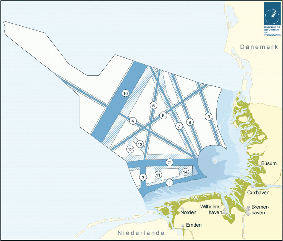 |
Presentation of the essential corner coordinates
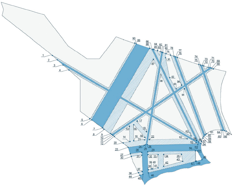 |
Nr.x-coordinatey-coordinateNr.x-Coordinatey-Coordinate
| 1 |
4 ° 23 ' 54, 44 " E |
55 ° 17 ' 58, 24 " N |
49 |
7 ° 32 ' 59, 40 " E |
54 ° 01'36 ,50 " N |
| 2 |
4 ° 30 ' 54, 63 " E |
55 ° 14 ' 28, 70 " N |
50 |
7 ° 24 ' 31, 38 " E |
54 ° 08 ' 08 ,50 " N |
| 3 |
4 ° 38 ' 09, 31 " E |
55 ° 10 ' 51, 61 " N |
51 |
7 ° 26 ' 54, 20 " E |
54 ° 08 ' 16, 12 " N |
| 4 |
4 ° 45 ' 07, 41 " E |
55 ° 07 ' 22, 49 " N |
52 |
7 ° 27 ' 44, 24 " E |
54 ° 13 ' 25, 33 " N |
| 5 |
5 ° 12 ' 44, 34 " E |
54 ° 31'37 ,53 " N |
53 |
7 ° 27 ' 30, 72 " E |
54 ° 13 ' 41, 47 " N |
| 6 |
5 ° 14 ' 07, 45 " E |
54 ° 31'01, 62 " N |
54 |
7 ° 31'30, 97 " E |
54 ° 13 ' 30, 69 " N |
| 7 |
5 ° 27 ' 57, 33 " E |
54 ° 25 ' 02 ,59 " N |
55 |
7 ° 28 ' 51, 11 " E |
54 ° 14 ' 25, 32 " N |
| 8 |
5 ° 37 ' 25, 43 " E |
54 ° 20 ' 56, 30 " N |
56 |
7 ° 26 ' 07 ,01 " E |
54 ° 15 ' 21, 39 " N |
| 9 |
5 ° 37 ' 52 ,05 " E |
54 ° 20 ' 44, 74 " N |
57 |
7 ° 32 ' 06, 87 " E |
54 ° 15 ' 03, 69 " N |
| 10 |
5 ° 39 ' 18, 82 " E |
54 ° 20 ' 07 ,09 " N |
58 |
7 ° 34 ' 02, 87 " E |
54 ° 17 ' 40, 17 " N |
| 11 |
5 ° 40 ' 48, 37 " E |
54 ° 19 ' 28, 21 " N |
59 |
7 ° 35 ' 11, 92 " E |
54 ° 18 ' 41.65 " N |
| 12 |
5 ° 42 ' 14, 71 " E |
54 ° 18 ' 50, 73 " N |
60 |
7 ° 36 ' 28, 88 " E |
54 ° 19 ' 37, 14 " N |
| 13 |
6 ° 01'59, 99 " E |
54 ° 26 ' 40, 43 " N |
61 |
7 ° 37 ' 47, 48 " E |
54 ° 20 ' 23, 89 " N |
| 14 |
6 ° 02 ' 02, 40 " E |
54 ° 14 ' 51 ,50 " N |
62 |
7 ° 14 ' 34, 37 " E |
54 ° 16 ' 57, 61 " N |
| 15 |
6 ° 06 ' 59, 98 " E |
54 ° 27 ' 38, 18 " N |
63 |
7 ° 19 ' 26, 32 " E |
54 ° 18 ' 46, 96 " N |
| 16 |
6 ° 07 ' 01, 78 " E |
54 ° 15 ' 15, 26 " N |
64 |
7 ° 56 ' 57, 17 " E |
54 ° 23 ' 26, 47 " N |
| 17 |
6 ° 10 ' 25 ,58 " E |
54 ° 30 ' 00, 40 " N |
65 |
7 ° 58 ' 50, 28 " E |
54 ° 23 ' 17, 45 " N |
| 18 |
6 ° 21'56, 72 " E |
54 ° 17 ' 49, 77 " N |
66 |
8 ° 00 ' 51, 91 " E |
54 ° 23 ' 00, 77 " N |
| 19 |
6 ° 23 ' 06, 27 " E |
54 ° 21'50, 23 " N |
67 |
8 ° 02 ' 54 ,51 " E |
54 ° 22 ' 35, 63 " N |
| 20 |
5 ° 53 ' 08, 20 " E |
54 ° 14 ' 08, 12 " N |
68 |
7 ° 47 ' 04, 96 " E |
55 ° 08 ' 05, 60 " N |
| 21 |
6 ° 21'29, 92 " E |
54 ° 16 ' 16, 72 " N |
69 |
7 ° 44 ' 49 ,02 " E |
55 ° 08 ' 24, 29 " N |
| 22 |
6 ° 26 ' 39 ,59 " E |
54 ° 16 ' 19, 42 " N |
70 |
7 ° 42 ' 28 ,07 " E |
55 ° 08 ' 43, 66 " N |
| 23 |
6 ° 00 ' 05, 70 " E |
54 ° 10 ' 51, 32 " N |
71 |
7 ° 40 ' 11 ,51 " E |
55 ° 09 ' 02, 42 " N |
| 24 |
6 ° 20 ' 33, 47 " E |
54 ° 12 ' 27, 42 " N |
72 |
7 ° 34 ' 38, 35 " E |
55 ° 09 ' 48, 19 " N |
| 25 |
6 ° 22 ' 06, 26 " E |
54 ° 12 ' 28 ,58 " N |
73 |
7 ° 32 ' 37, 63 " E |
55 ° 10 ' 06, 25 " N |
| 26 |
6 ° 23 ' 53, 60 " E |
54 ° 12 ' 29, 96 " N |
74 |
7 ° 30 ' 28, 80 " E |
55 ° 10 ' 30, 91 " N |
| 27 |
6 ° 02 ' 51, 34 " E |
54 ° 06 ' 03, 15 " N |
75 |
7 ° 28 ' 24 ,51 " E |
55 ° 10 ' 54, 69 " N |
| 28 |
6 ° 17 ' 34, 43 " E |
54 ° 07 ' 12 ,59 " N |
76 |
7 ° 01'48, 70 " E |
55 ° 15 ' 59, 71 " N |
| 29 |
6 ° 24 ' 20, 80 " E |
54 ° 07 ' 30, 62 " N |
77 |
6 ° 59 ' 41.79 " E |
55 ° 16 ' 23, 95 " N |
| 30 |
6 ° 03 ' 57, 96 " E |
54 ° 04 ' 07, 67 " N |
78 |
6 ° 57 ' 30, 11 " E |
55 ° 16 ' 49 ,08 " N |
| 31 |
6 ° 17 ' 40 ,54 " E |
54 ° 05 ' 12, 32 " N |
79 |
6 ° 53 ' 13, 18 " E |
55 ° 17 ' 38 ,05 " N |
| 32 |
6 ° 24 ' 27, 73 " E |
54 ° 05 ' 31 ,04 " N |
80 |
6 ° 47 ' 25, 80 " E |
55 ° 18 ' 44, 28 " N |
| 33 |
6 ° 37 ' 36 ,00 " E |
54 ° 05 ' 40, 61 " N |
81 |
6 ° 43 ' 32, 95 " E |
55 ° 19 ' 28, 78 " N |
| 34 |
6 ° 44 ' 24 ,00 " E |
54 ° 05 ' 45 ,56 " N |
82 |
6 ° 41'49, 28 " E |
55 ° 19 ' 48 ,54 " N |
| 35 |
7 ° 06 ' 55 ,50 " E |
54 ° 06 ' 02, 10 " N |
83 |
6 ° 40 ' 09, 30 " E |
55 ° 20 ' 07, 60 " N |
| 36 |
6 ° 12 ' 54, 60 " E |
53 ° 52 ' 13, 41 " N |
84 |
6 ° 36 ' 24, 20 " E |
55 ° 20 ' 50 ,50 " N |
| 37 |
6 ° 18 ' 16, 35 " E |
53 ° 53 ' 15, 76 " N |
85 |
6 ° 31'44, 25 " E |
55 ° 21'43, 83 " N |
| 38 |
6 ° 25 ' 07, 16 " E |
53 ° 54 ' 17, 48 " N |
86 |
6 ° 29 ' 20, 21 " E |
55 ° 22 ' 11, 27 " N |
| 39 |
6 ° 29 ' 24 ,00 " E |
53 ° 54 ' 53 ,00 " N |
87 |
6 ° 31'43, 47 " E |
55 ° 14 ' 53, 15 " N |
| 40 |
6 ° 30 ' 49 ,57 " E |
53 ° 54 ' 53 ,00 " N |
88 |
6 ° 27 ' 08, 45 " E |
55 ° 22 ' 36, 36 " N |
| 41 |
6 ° 37 ' 36 ,00 " E |
53 ° 55 ' 50, 75 " N |
89 |
6 ° 10 ' 07, 73 " E |
55 ° 25 ' 50 ,57 " N |
| 42 |
6 ° 44 ' 24 ,00 " E |
53 ° 56 ' 48, 70 " N |
90 |
6 ° 08 ' 25, 63 " E |
55 ° 26 ' 09, 99 " N |
| 43 |
7 ° 08 ' 36, 23 " E |
54 ° 00 ' 32, 81 " N |
91 |
6 ° 46 ' 43, 72 " E |
55 ° 16 ' 05, 65 " N |
| 44 |
6 ° 14 ' 39, 31 " E |
53 ° 50 ' 09, 81 " N |
92 |
6 ° 52 ' 06, 97 " E |
55 ° 01'36, 82 " N |
| 45 |
6 ° 18 ' 23, 37 " E |
53 ° 50 ' 53 ,00 " N |
93 |
7 ° 00 ' 00 ,51 " E |
54 ° 53 ' 16, 96 " N |
| 46 |
6 ° 25 ' 15 ,04 " E |
53 ° 52 ' 01, 95 " N |
94 |
7 ° 07 ' 20, 95 " E |
54 ° 56 ' 07, 14 " N |
| 47 |
7 ° 24 ' 31, 33 " E |
54 ° 00 ' 26, 83 " N |
95 |
7 ° 10 ' 42, 42 " E |
54 ° 53 ' 47, 61 " N |
| 48 |
7 ° 24 ' 36, 37 " E |
54 ° 00 ' 25, 66 " N |
96 |
6 ° 40 ' 48 ,04 " E |
55 ° 04 ' 19, 27 " N |
-
6.1.2
-
Piping and submarine cables
Nrx Coordinate Coordinate
| 1 |
6 ° 33 ' 47 ,03 " E |
54 ° 5 ' 37, 83 " N |
| 2 |
6 ° 37 ' 36 ,00 " E |
54 ° 2 ' 35 ,03 " N |
| 3 |
6 ° 37 ' 36 ,00 " E |
54 ° 3 ' 29, 25 " N |
| 4 |
6 ° 34 ' 54, 42 " E |
54 ° 5 ' 38, 65 " N |
| 5 |
6 ° 47 ' 39, 66 " E |
54 ° 5 ' 47, 94 " N |
| 6 |
6 ° 56 ' 00 ,00 " E |
54 ° 0 ' 20, 23 " N |
| 7 |
6 ° 56 ' 00 ,00 " E |
54 ° 1'06, 90 " N |
| 8 |
6 ° 48 ' 53, 11 " E |
54 ° 5 ' 48, 83 " N |
Note:
The priority and reserved areas for pipelines in the North Sea shall be limited by a corridor from both sides 500 metres parallel to the existing pipeline. Due to the large number of coordinates, a single listing is not possible.
-
6.1.3
-
Research
Nrx Coordinate Coordinate
| 1 |
4 ° 40 ' 00, 12 " E |
55 ° 19 ' 59, 88 " N |
| 2 |
4 ° 40 ' 00, 12 " E |
55 ° 10 ' 00, 12 " N |
| 3 |
4 ° 58 ' 00, 12 " E |
55 ° 10 ' 00, 12 " N |
| 4 |
4 ° 58 ' 00, 12 " E |
55 ° 19 ' 10, 23 " N |
| 5 |
4 ° 55 ' 51, 28 " E |
55 ° 19 ' 59, 88 " N |
| 6 |
6 ° 57 ' 55, 30 " E |
54 ° 26 ' 57 ,53 " N |
| 7 |
6 ° 57 ' 55, 32 " E |
54 ° 16 ' 57 ,51 " N |
| 8 |
7 ° 14 ' 55, 34 " E |
54 ° 16 ' 57 ,51 " N |
| 9 |
7 ° 14 ' 55, 32 " E |
54 ° 26 ' 57 ,54 " N |
| 10 |
7 ° 29 ' 55, 30 " E |
54 ° 52 ' 57, 60 " N |
| 11 |
7 ° 29 ' 55, 32 " E |
54 ° 42 ' 57 ,58 " N |
| 12 |
7 ° 47 ' 55, 35 " E |
54 ° 42 ' 57 ,59 " N |
| 13 |
7 ° 47 ' 55, 33 " E |
54 ° 52 ' 57, 61 " N |
-
6.1.4
-
Wind energy
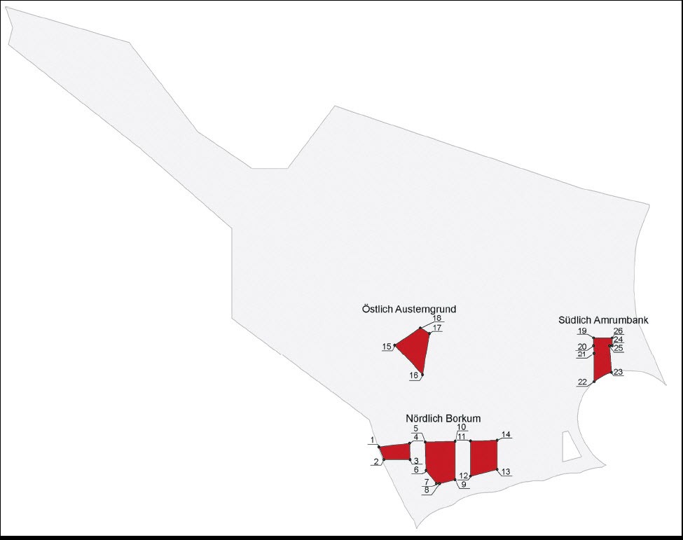 |
Nr.x-coordinatey-coordinateNr.x-Coordinatey-Coordinate
| 1 |
6 ° 04 ' 17 ,04 " E |
54 ° 04 ' 09, 13 " N |
14 |
6 ° 55 ' 60 ,00 " E |
54 ° 05 ' 54 ,01 " N |
| 2 |
6 ° 06 ' 24, 97 " E |
54 ° 00 ' 59, 97 " N |
15 |
6 ° 11'12, 11 " E |
54 ° 30 ' 18, 71 " N |
| 3 |
6 ° 17 ' 53, 39 " E |
54 ° 00 ' 59, 21 " N |
16 |
6 ° 23 ' 18, 13 " E |
54 ° 22 ' 31, 19 " N |
| 4 |
6 ° 17 ' 40 ,54 " E |
54 ° 05 ' 12, 32 " N |
17 |
6 ° 26 ' 25, 92 " E |
54 ° 33 ' 19 ,51 " N |
| 5 |
6 ° 24 ' 27, 73 " E |
54 ° 05 ' 31 ,04 " N |
18 |
6 ° 22 ' 20, 42 " E |
54 ° 34 ' 42, 66 " N |
| 6 |
6 ° 24 ' 53 ,08 " E |
53 ° 58 ' 12 ,51 " N |
19 |
7 ° 38 ' 15, 61 " E |
54 ° 32 ' 12 ,01 " N |
| 7 |
6 ° 29 ' 24 ,00 " E |
53 ° 54 ' 53 ,00 " N |
20 |
7 ° 38 ' 15, 61 " E |
54 ° 30 ' 13, 79 " N |
| 8 |
6 ° 30 ' 49 ,57 " E |
53 ° 54 ' 53 ,00 " N |
21 |
7 ° 38 ' 26 ,02 " E |
54 ° 28 ' 14, 99 " N |
| 9 |
6 ° 37 ' 36 ,00 " E |
53 ° 55 ' 50, 75 " N |
22 |
7 ° 38 ' 28, 68 " E |
54 ° 20 ' 48, 12 " N |
| 10 |
6 ° 37 ' 36 ,00 " E |
54 ° 05 ' 40, 61 " N |
23 |
7 ° 46 ' 02 ,06 " E |
54 ° 23 ' 07, 27 " N |
| 11 |
6 ° 44 ' 24 ,00 " E |
54 ° 05 ' 45 ,56 " N |
24 |
7 ° 45 ' 06, 81 " E |
54 ° 30 ' 13, 82 " N |
| 12 |
6 ° 44 ' 24 ,00 " E |
53 ° 56 ' 48, 70 " N |
25 |
7 ° 46 ' 22, 19 " E |
54 ° 30 ' 13, 79 " N |
| 13 |
6 ° 55 ' 60 ,00 " E |
53 ° 58 ' 27, 49 " N |
26 |
7 ° 46 ' 22, 19 " E |
54 ° 32 ' 12 ,01 " N |
-
6.2
-
Transnational pipelines in the North Sea
PDF document is displayed in your own window
PDF document is displayed in your own window